 Filter: Categories of Wisconsin Historical Images
Filter: Subject of Streets
Filter: Subject of indians of north america
Filter: Categories of Wisconsin Historical Images
Filter: Subject of Streets
Filter: Subject of indians of north america

| Date: | 1873 |
|---|---|
| Description: | Bird's-eye map of La Crosse from the Mississippi River. |
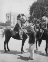
| Date: | 07 09 1930 |
|---|---|
| Description: | Mayor Albert G. Schmedeman greeting Chief Shunatuna, who is on horseback and who is in Madison with the Official United States Indian band at the RKO Orphe... |
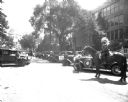
| Date: | 07 09 1930 |
|---|---|
| Description: | A man on a horse with Pontiac cars lined up on Wisconsin Avenue for the U.S. Indian Band parade, with the Wisconsin State Capitol in the background. They p... |
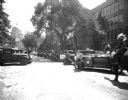
| Date: | 07 09 1930 |
|---|---|
| Description: | A man on a horse with Pontiac cars lined up on Wisconsin Avenue for the US Indian Band parade with State Capitol in the background. They played a concert a... |
| Date: | |
|---|---|
| Description: | Native American man, and two women in a wagon pulled by a single horse. Storefronts include a jeweler on the left with an awning advertising books and stat... |
| Date: | |
|---|---|
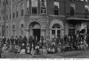
| Description: | A group of Native American men, women, and children, waiting in front of the First National Bank for their payment, possibly in 1910. Caption reads: "India... |

| Date: | 10 21 1855 |
|---|---|
| Description: | Map of the Wisconsin and the Minnesota Territory showing the status of township surveys in Wisconsin and southeastern Minnesota. The Wisconsin reservation... |
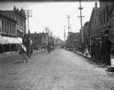
| Date: | 07 28 1901 |
|---|---|
| Description: | View down Main Street, facing east, during Pawnee Bill's Circus Wild West Parade. |
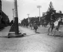
| Date: | 06 03 1901 |
|---|---|
| Description: | View of Pawnee Bill's Wild West Parade, looking west down Main Street. |

| Date: | 1854 |
|---|---|
| Description: | Shows street grid, sections in adjacent townships, routes of railroads and projected railroads, post offices, and creeks. Table of references identifies ma... |

| Date: | |
|---|---|
| Description: | Map showing Indian mounds in Milwaukee's Second Ward from a sketch made by Increase Lapham in 1836. Streets shown on the map include 6th Street, 5th Street... |

| Date: | |
|---|---|
| Description: | View across unpaved road towards a Native American woman, wrapped in a plaid shawl, walking in front of a horse hitched to a wagon. On the left across the ... |

| Date: | 1933 |
|---|---|
| Description: | Blue print and blue line print maps that show local streets, Nakoma Country Club, part of Lake Forest, and part of Lake Wingra. A legend is included that s... |

| Date: | 1945 |
|---|---|
| Description: | This maps shows roads, railroads, parks, recreational areas, Lake Wingra, Lake Monona, and part of Lake Mendota. The map includes pictorial images that dep... |

| Date: | 1838 |
|---|---|
| Description: | This map is a development plat that shows street names, numbered blocks and lots, and small farm lot owners. Included on the right of the map is a large am... |

| Date: | 1974 |
|---|---|
| Description: | This map draws content from a map originally created by George Featherstongaugh in 1840. The map shows streets, land ownership, the Brotherton Indian reser... |

| Date: | 1930 |
|---|---|
| Description: | View across muddy ground towards a man holding a dairy cow by the halter, and on the left a boy holding the lead of a heifer. They are standing in front of... |
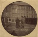
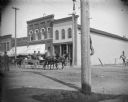
| Date: | 01 1892 |
|---|---|
| Description: | George Goodvillage and his wife posing on King Street. In the background is a row of commercial buildings. The building on the left is a Saddlery. The tele... |

| Date: | 1760 |
|---|---|
| Description: | Map showing upstate New York, Lake Ontario, and the St. Lawrence River during the last, decisive battle of the French and Indian War. The main map shows a ... |
If you didn't find the material you searched for, our Library Reference Staff can help.
Call our reference desk at 608-264-6535 or email us at:
