Filter: Categories of Wisconsin Historical Images
Filter: Subject of Streets
Filter: Subject of boats and boating
Filter: Categories of Wisconsin Historical Images
Filter: Subject of Streets
Filter: Subject of boats and boating

| Date: | 1870 |
|---|---|
| Description: | This bird's-eye-view map shows roads, a river with boats, and homes. The bottom margin of the map includes an index. |
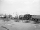
| Date: | 04 24 1931 |
|---|---|
| Description: | Boathouses on Lake Monona looking southeast from E. Wilson Street across CNW railroad tracks. View of Wirka Boat Line, E. Wilson Street at S. Hancock Stree... |
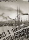
| Date: | |
|---|---|
| Description: | Elevated view of Milwaukee River from Walker's Point Bridge. |

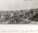
| Date: | 1868 |
|---|---|
| Description: | This 1868 birds-eye view depicts the buildings, streets, railroad, vegetation and topography of Columbus, Wisconsin. The high school, cemetery, railroad de... |

| Date: | 1873 |
|---|---|
| Description: | Bird's-eye map of La Crosse from the Mississippi River. |

| Date: | 1898 |
|---|---|
| Description: | Bird's-eye map of Milwaukee with prominent streets and buildings identified. Taken from City Hall Tower. |

| Date: | 1874 |
|---|---|
| Description: | Bird's-eye map of Chippewa Falls. |

| Date: | 1877 |
|---|---|
| Description: | Bird's-eye map of Janesville on the Rock River. |
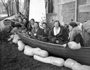
| Date: | 11 14 1931 |
|---|---|
| Description: | University of Wisconsin coeds sitting in a boat surrounded by sand bags in front of Ann Emery Hall, 265 Langdon Street, an independent women's dormitory. I... |

| Date: | 09 28 1929 |
|---|---|
| Description: | Texaco racing boats on display at a service station, at 632 University Avenue. Next door on the right is the Wheeler Conservatory of Music at 626 Universit... |

| Date: | 1874 |
|---|---|
| Description: | Bird's-eye view of Waukesha, looking southwest, with insets of State Industrial School, Court House, and Fountain Spring House. |

| Date: | 1870 |
|---|---|
| Description: | Bird's-eye view of Whitewater, with insets. |

| Date: | 1949 |
|---|---|
| Description: | Color bird's-eye map of the University of Wisconsin-Madison as it was midcentury, with two co-eds, several photographs of campus landmarks around edges, an... |
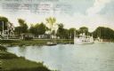
| Date: | 1908 |
|---|---|
| Description: | View from shoreline towards a large boat, perhaps an excursion boat, and sailboats docked further down along the curving shoreline. Beyond the boats is a t... |
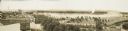
| Date: | 1900 |
|---|---|
| Description: | Four-panel Panoramic view of La Crosse. Indentifiable businesses in view include: J. Hogan Wholesale Grocer, T.H. Spence Drug Co., Union Refrigerator Trans... |
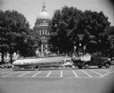
| Date: | 07 04 1952 |
|---|---|
| Description: | "Comely young women" ride the float of the Four Lakes Yachting Club in the 1952 Fourth of July parade on Capitol Square for the East Side Businessmen's Ass... |
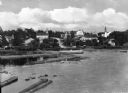
| Date: | |
|---|---|
| Description: | View of Eagle Harbor and the area surrounding Church Street. On the right, Ephraim Moravian Church, completed in 1859, can be seen among residential buildi... |
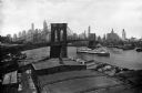
| Date: | 1910 |
|---|---|
| Description: | View of the East River and the Brooklyn Bridge. Several boats and ships sail down the river and industrial buildings and skyscrapers stand in the foregroun... |
If you didn't find the material you searched for, our Library Reference Staff can help.
Call our reference desk at 608-264-6535 or email us at: