Filter: Categories of Wisconsin Historical Images
Filter: Subject of Streets
Filter: County of Dodge
Filter: Categories of Wisconsin Historical Images
Filter: Subject of Streets
Filter: County of Dodge

| Date: | 09 1994 |
|---|---|
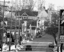
| Description: | Crowd looks on as crew demolishes building across street. |
| Date: | 08 1995 |
|---|---|
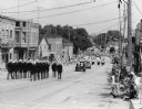
| Description: | Street view of Theresa Firemen's Parade. |
| Date: | 1995 |
|---|---|
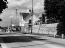
| Description: | A shot of a snowy Main Street in Theresa, Wisconsin. |

| Date: | 08 1996 |
|---|---|
| Description: | A shot of Theresa's Sesquicentennial parade. |
| Date: | 1996 |
|---|---|
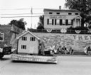
| Description: | Replica of Solomon Juneau's house in Theresa Parade. Juneau is credited with founding the town. |
| Date: | 01 1999 |
|---|---|
| Description: | Krueger's Empire Hotel, the building that stood on the South West corner of Milwaukee and Rock River streets, has been razed. |

| Date: | 05 1999 |
|---|---|
| Description: | An addition was made to the hall to accommodate additional offices. |

| Date: | 11 1999 |
|---|---|
| Description: | Edgar Mueller rides his bicycle down the streets of Mayville. |

| Date: | 09 2002 |
|---|---|
| Description: | Ron Redman, Theresa's "Walking Man" spends a good part of the day walking up and down the streets of Theresa. |

| Date: | 1856 |
|---|---|
| Description: | This map shows a plat of the town, local streets, lots, and part of the Rock River. The margins of the map have manuscript annotations in ink. |

| Date: | 1868 |
|---|---|
| Description: | This map is ink on tracing cloth and shows lot and block numbers, depot, railroads and side tracks, and streets in sections 24 and 25, T.11, R.16E. The map... |

| Date: | 1968 |
|---|---|
| Description: | This blue line print shows lot numbers and dimensions, existing or platted streets and highways, streets and highways to be widened, future streets, and vi... |

| Date: | 1926 |
|---|---|
| Description: | Two women are bending over in front of the plow on the left, pretending to pull a woman sitting on the back of the plow which is parked near a residential ... |

| Date: | 1900 |
|---|---|
| Description: | This map shows landownership and buildings in the community in 1876. An inset map shows Plan of Corporation of Mayville. The upper left corner includes a b... |

| Date: | |
|---|---|
| Description: | View down center of a city street, which is lined with bars, restaurants and other businesses. Automobiles are parked at an angle at the curbs. Caption rea... |

| Date: | |
|---|---|
| Description: | Photographic postcard view down center of street towards a commercial district. There are car dealerships, gas stations and other businesses, with automobi... |
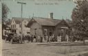
| Date: | 1913 |
|---|---|
| Description: | View across railroad tracks towards the railroad depot, with several passengers standing on the platform. An automobile is parked at the curb. Caption read... |

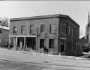
| Date: | 1919 |
|---|---|
| Description: | Exterior view of R.H. Runge's General Merchandise store. A woman and two men are standing near the entrance. Penciled-in note on reverse reads: "Burned ... |
If you didn't find the material you searched for, our Library Reference Staff can help.
Call our reference desk at 608-264-6535 or email us at: