 Filter: Categories of Wisconsin Historical Images
Filter: Subject of Streets
Filter: Community of Wauwatosa
Filter: Categories of Wisconsin Historical Images
Filter: Subject of Streets
Filter: Community of Wauwatosa

| Date: | 1947 |
|---|---|
| Description: | This map of Wauwatosa shows 10 zoning class types of land including residential, manufacturing, and business. The map also shows government buildings, some... |

| Date: | 1939 |
|---|---|
| Description: | This is a zoning map of Wauwatosa with a key of districts including agricultural, resident, business, commercial, and industrial. The map features labeled ... |
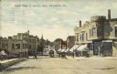
| Date: | 05 30 1911 |
|---|---|
| Description: | Text on front reads: "North Main St. looking West, Wauwatosa, Wis." Streetcars on an unpaved street with horse-drawn vehicles and pedestrians. The street i... |
If you didn't find the material you searched for, our Library Reference Staff can help.
Call our reference desk at 608-264-6535 or email us at: