 Filter: Categories of Wisconsin Historical Images
Filter: Subject of Streets
Filter: Community of Milwaukee
Filter: Year of 1800-1899
Filter: Year of 1880-1889
Filter: Categories of Wisconsin Historical Images
Filter: Subject of Streets
Filter: Community of Milwaukee
Filter: Year of 1800-1899
Filter: Year of 1880-1889
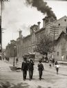
| Date: | 1888 |
|---|---|
| Description: | Exterior of Schlitz Brewing Company with two men and a boy in suits and hats in the foreground. |
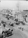
| Date: | 1885 |
|---|---|
| Description: | Elevated view of a farmer's market with horse-drawn vehicles. One man is leading a bull down the street. |
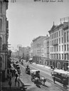
| Date: | 1885 |
|---|---|
| Description: | Elevated view down East Water Street from Wisconsin Avenue, with buildings, people, and street traffic including horse-drawn vehicles and a horse-drawn str... |
| Date: | 1885 |
|---|---|
| Description: | German Market on the right side of the street in the distance. Two horse-drawn vehicles in the foreground are heading toward the market. Pedestrians are wa... |
| Date: | 07 03 1886 |
|---|---|
| Description: | The east side of the Schlitz Palm Garden at N. 3rd Street, south of W. Wisconsin Avenue. The Schlitz Palm Garden opened on July 3, 1886 and was one of the ... |
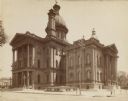
| Date: | 1885 |
|---|---|
| Description: | View from street of courthouse on street corner. |

| Date: | 01 09 1883 |
|---|---|
| Description: | A large crowd is on the street surrounding the burning building. Fire fighters are struggling with horses pulling the fire engine, and on the left a group... |

| Date: | 10 1887 |
|---|---|
| Description: | A parade for President Grover Cleveland's Milwaukee visit during his Goodwill Tour. A marching band leads a horse and buggy (possibly carrying the presiden... |

| Date: | 1880 |
|---|---|
| Description: | Map created from original drawing and surveys taken by Silas Chapman. Bottom right corner features a reference key. There is a street guide on the left sid... |
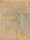
| Date: | 1886 |
|---|---|
| Description: | The map reads: "Compiled under the direction of the J.V. DUPRE ABSTRACT CO. from Dupre’s 1/4 Sectn’l Atlas of Milwaukee, by G. Steinhagen, C.E." The map co... |

| Date: | 1888 |
|---|---|
| Description: | Map of Milwaukee "Compiled under the direction of the J.V. DUPRE ABSTRACT CO., from Dupre’s 1/4-Sectn’l Atlas of Milwaukee, by G. Steinhagen, C.E." Contain... |
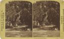
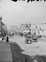
| Date: | 1885 |
|---|---|
| Description: | View along Van Buren Street, looking north from Mason Street. Three children are sitting on the curb at the corner. |

| Date: | 1887 |
|---|---|
| Description: | This map shows sewers, manholes, streets, canals, rivers, and Lake Michigan. An explanation of sewer types is included. |
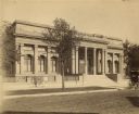
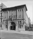
| Date: | 1888 |
|---|---|
| Description: | View across street towards the facade of the original Layton Art Gallery building at 758 N. Jefferson Street. Two men stand at the top of the stairs betwee... |

| Date: | 1880 |
|---|---|
| Description: | This map shows wards, roads, railroads, lot and block numbers, subdivisions, parks, and some landownership. A handwritten annotation in red reads: "Note: S... |

| Date: | 01 1883 |
|---|---|
| Description: | Photograph of an engraved image showing an elevated view of the Newhall House fire. A large crowd is gathered in the foreground observing the fire and fire... |

| Date: | 1880 |
|---|---|
| Description: | A map of Milwaukee which includes a city street guide. |
If you didn't find the material you searched for, our Library Reference Staff can help.
Call our reference desk at 608-264-6535 or email us at: