 Filter: Categories of Wisconsin Historical Images
Filter: Subject of Streets
Filter: Community of Milwaukee
Filter: Subject of school buildings
Filter: Categories of Wisconsin Historical Images
Filter: Subject of Streets
Filter: Community of Milwaukee
Filter: Subject of school buildings
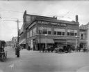
| Date: | 04 01 1915 |
|---|---|
| Description: | Northwest corner of 3rd and Wells Street, facing the Milwaukee Commercial School. A police officer directs traffic in the foreground, with pedestrians on t... |

| Date: | |
|---|---|
| Description: | Exterior view across street toward the high school. Caption reads: "West Side High School, Milwaukee." |

| Date: | 1938 |
|---|---|
| Description: | Children standing in line, boarding an International D-300 bus near what appears to be a school building. This bus was equipped with 165" Hicks body. |

| Date: | 1857 |
|---|---|
| Description: | This map shows lot and block numbers, wards, roads, railroads, some landowners’ names, and selected buildings. The map includes an inset map of Glidden & L... |

| Date: | 1857 |
|---|---|
| Description: | This map shows lot and block numbers, wards, roads, railroads, some landowners’ names, and selected buildings. Lake Michigan, the Milwaukee River, and Glid... |

| Date: | 1857 |
|---|---|
| Description: | This map shows lot and block numbers, wards, roads, railroads, some landowners’ names, and selected buildings. Lake Michigan, the Milwaukee River, and Glid... |

| Date: | 1910 |
|---|---|
| Description: | A Sanborn insurance map of Milwaukee, including the shore of Lake Michigan. |
If you didn't find the material you searched for, our Library Reference Staff can help.
Call our reference desk at 608-264-6535 or email us at: