 Filter: Categories of Wisconsin Historical Images
Filter: Subject of Streets
Filter: Community of Mauston
Filter: Categories of Wisconsin Historical Images
Filter: Subject of Streets
Filter: Community of Mauston

| Date: | 11 1957 |
|---|---|
| Description: | Photograph taken by the State Highway Department to show the condition of curbs and gutters along STH 12 in Mauston, also documenting the original brick su... |

| Date: | 1905 |
|---|---|
| Description: | View down tree-lined sidewalk, with Division Street on the right. Caption reads: "Division St. Looking South, Mauston, Wis." |

| Date: | 1905 |
|---|---|
| Description: | View down wide, unpaved street with businesses and storefronts on both sides. Caption reads: "State Street, Mauston, Wis." |

| Date: | 1905 |
|---|---|
| Description: | View down wide, unpaved street with businesses and storefronts on both sides. Captions read: "Mauston, Wis." and "State Street." |

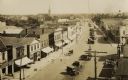
| Date: | 1905 |
|---|---|
| Description: | Elevated view of State Street. There is a parade coming down the street, and crowds are on the sidewalks. Caption reads: "State Street, Looking East, Maust... |

| Date: | |
|---|---|
| Description: | View across intersection towards storefronts on the left. On the corner is the Post Office, and further down are signs for the "Exide Battery Station," and... |
| Date: | 1920 |
|---|---|
| Description: | Elevated view of town. There is an unusual automobile parking pattern in the center of State Street. There is a sign for "Billiards" on a building in the r... |

| Date: | 1911 |
|---|---|
| Description: | Exterior of the Methodist Evangelical Church. A small boy sits on the curb along the cobblestone street outside the building. Next door to the church is Ho... |

| Date: | 1911 |
|---|---|
| Description: | View down street towards the exterior of the Catholic Church, where a horse is tied to a tree nearby. |

| Date: | 1911 |
|---|---|
| Description: | View down brick paved Main Street. A horse and carriage travels along the street. Caption reads: "Scene on Main St., Mauston, Wis." |

| Date: | |
|---|---|
| Description: | This plat map shows numbered blocks and lots, local streets, the La Crosse and Milwaukee Railroad, and part of the Lemonwier [i.e. Lemonweir] River. |

| Date: | 1958 |
|---|---|
| Description: | This blue line print map shows lot and block numbers and dimensions, additions, and some landownership. The Lawrence River is labeled. |
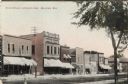
| Date: | 1908 |
|---|---|
| Description: | View of a block of storefronts, many with awnings over the windows. Caption reads: "State Street, Opposite Park, Mauston, Wis." |

| Date: | |
|---|---|
| Description: | Exterior view across road toward the church and school. Caption reads: "St. Patrick Church and School, Mauston, Wis." |
| Date: | 10 10 1913 |
|---|---|
| Description: | View looking down towards two men standing on a sidewalk in a residential neighborhood after a tornado. There are damaged trees, and part of a wooden wall ... |

| Date: | 1910 |
|---|---|
| Description: | View down street in the central business district. Caption reads: "State St. Looking West — Mauston, Wis." |
If you didn't find the material you searched for, our Library Reference Staff can help.
Call our reference desk at 608-264-6535 or email us at: