 Filter: Categories of Wisconsin Historical Images
Filter: Subject of Streets
Filter: Community of Manitowoc
Filter: Categories of Wisconsin Historical Images
Filter: Subject of Streets
Filter: Community of Manitowoc

| Date: | 1950 |
|---|---|
| Description: | An aerial view of town, showing a major industrial area. |

| Date: | 1920 |
|---|---|
| Description: | View across street toward the library. Caption reads: "Public Library, Manitowoc, Wis." |

| Date: | 1907 |
|---|---|
| Description: | View up street with a large building on the corner on the right, and church buildings further down the street. Caption reads: "View up South Eigth Street f... |

| Date: | 1920 |
|---|---|
| Description: | St. James Episcopal Church in Manitowoc. |
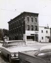
| Date: | 1964 |
|---|---|
| Description: | A mercantile building across Sixth Street from the Windiate Hotel, built in 1854. Automobiles are parked in the foreground. |
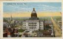
| Date: | 1925 |
|---|---|
| Description: | Elevated view of Manitowoc, dominated by the Manitowoc County Court House. Caption reads: "Bird's-eye View, Manitowoc, Wis." |

| Date: | 1951 |
|---|---|
| Description: | Sunday morning traffic on the corner of Washington and South 8th Streets in Manitowoc. |
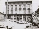
| Date: | 1964 |
|---|---|
| Description: | The Windiate Hotel located at York and Sixth Streets. The hotel was erected in 1854 and opened the same time as the mercantile store across the street. The... |

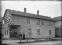
| Date: | |
|---|---|
| Description: | Exterior view of two buildings which comprise Holy Family Hospital. |

| Date: | |
|---|---|
| Description: | Letterhead of the William Rahr Sons' Company of Manitowoc, Wisconsin, "Maltsters and Roasters," with an elevated view of the company building on one side o... |

| Date: | 1962 |
|---|---|
| Description: | View across road towards loading dock of the Kingsbury Brewing Company. Printed on the side of the building are two advertisements for Kingsbury Beer. |
| Date: | 1902 |
|---|---|
| Description: | Exterior image of the Union Saloon. The saloon was owned by Joseph Krainik. Three men are standing on the entrance steps of the building and two men are st... |

| Date: | 01 1899 |
|---|---|
| Description: | Shows lot and block numbers, railroads, ward boundaries, and some landownership. Includes public building index. |
| Date: | 1945 |
|---|---|
| Description: | Map features a legend with symbols of points of interest. The symbols are in red. The back of the map has text on "Points of Interest and Information". |

| Date: | 1950 |
|---|---|
| Description: | Aerial view showing shipyards, rivers and roads. |

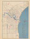
| Date: | 1905 |
|---|---|
| Description: | This map shows a plat of the city, local streets, railroads, public buildings, local businesses, and parts of the Manitowoc River and Lake Michigan. Relief... |

| Date: | |
|---|---|
| Description: | This plat map shows numbered blocks and lots, wards, local streets, railroads, cemeteries, buildings, land ownership by name, and parts of Manitowoc River ... |

| Date: | 1925 |
|---|---|
| Description: | This map shows a plat of the city, local streets, railroads, public buildings, local businesses, and parts of the Manitowoc River and Lake Michigan. Relief... |

| Date: | 1856 |
|---|---|
| Description: | This map shows the Manitowoc River, Lake Michigan, streets, and buildings. Relief is shown by hachures and soundings are in feet and decimals of a foot. Th... |

| Date: | 09 1853 |
|---|---|
| Description: | This map shows streets, docks, warehouses, and piers near the harbor. The Manitowoc River and Lake Michigan are labeled. Depths are indicated by soundings ... |
If you didn't find the material you searched for, our Library Reference Staff can help.
Call our reference desk at 608-264-6535 or email us at: