 Filter: Categories of Wisconsin Historical Images
Filter: Subject of Streets
Filter: Community of Kenosha
Filter: Categories of Wisconsin Historical Images
Filter: Subject of Streets
Filter: Community of Kenosha
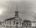
| Date: | 1900 |
|---|---|
| Description: | A Baptist church in Kenosha built in 1848 that is now no longer standing. |
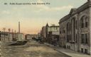
| Date: | 1910 |
|---|---|
| Description: | View down street toward the Kenosha City Hall and Public Square. Caption reads: "Public Square and City Hall, Kenosha, Wis." |
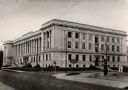
| Date: | 1925 |
|---|---|
| Description: | The third of Kenosha County courthouses, located on the corner of Sheridan and 56th Street. The courthouse cost $1,000,000 to construct. In the foreground ... |

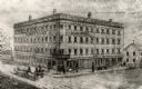
| Date: | 1915 |
|---|---|
| Description: | Elevated view of the hotel on a street corner. Caption reads: "New Hotel Dayton, Kenosha, Wisc." |
| Date: | 1860 |
|---|---|
| Description: | Elevated view of the Durkee House built by Charles Durkee in 1843. |

| Date: | 1870 |
|---|---|
| Description: | View across intersection towards Kimball's Hall, one of the first brick buildings in Kenosha. A sign on the right side of the building reads: "Dewey & Sinc... |
| Date: | 1872 |
|---|---|
| Description: | Elevated view looking down Main Street. There are horse-drawn vehicles, and pedestrians are walking on the street and sidewalks. |

| Date: | 05 12 1898 |
|---|---|
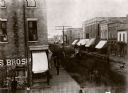
| Description: | View down center of street with shops and stores on either side of Main Street. |

| Date: | 1920 |
|---|---|
| Description: | The home of Milton H. Pettit, built about 1899. |
| Date: | 1908 |
|---|---|
| Description: | View down street toward St. Matthews Church and surrounding buildings. Pedestrians and dogs are walking on the street and sidewalks. Caption reads: "St. Ma... |

| Date: | 1910 |
|---|---|
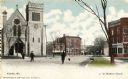
| Description: | View across street towards the church. Caption reads: "St. Matthews Church, Kenosha, Wis." |
| Date: | 1930 |
|---|---|
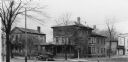
| Description: | Tenth and Fifty-seventh Streets, with early houses, car and barn. |

| Date: | 1900 |
|---|---|
| Description: | View across intersection toward a building on the street corner. Caption reads: "Wisconsin Street, Kenosha, Wis." |
| Date: | 1934 |
|---|---|
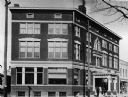
| Description: | The second YMCA building in Kenosha. It was used as a commercial structure at the time of the photograph. |

| Date: | 1948 |
|---|---|
| Description: | This map shows wards and precincts and includes a list of polling places by ward and precinct. The map reads: "Keep this Map . . . It Gives the Location of... |

| Date: | 1953 |
|---|---|
| Description: | This map is a blue line print and shows streets as well as some points of interest. |

| Date: | 1948 |
|---|---|
| Description: | This map shows a list of polling places by ward and precinct in the left margin, a list of assembly districts, and additional handwritten notes. Lake Michi... |

| Date: | 1961 |
|---|---|
| Description: | This is a photocopy of a map in blue line print that shows streets and places of interest. Inscribed in pen, at the bottom of the map, reads: "Sen. Zaborsk... |

| Date: | 1857 |
|---|---|
| Description: | This map was created from a survey made in December 1855 and shows local streets, proposed roads, railroads, the lake shore, bridge wharfs, the basin, the ... |

| Date: | 1910 |
|---|---|
| Description: | This map is a survey of Kenosha Harbor and shows local streets, public buildings, local businesses, and part of Lake Michigan. Included is text on sailing ... |
If you didn't find the material you searched for, our Library Reference Staff can help.
Call our reference desk at 608-264-6535 or email us at: