Filter: Categories of Wisconsin Historical Images
Filter: Subject of Streets
Filter: Community of Green Bay
Filter: Year of 1800-1899
Filter: Categories of Wisconsin Historical Images
Filter: Subject of Streets
Filter: Community of Green Bay
Filter: Year of 1800-1899

| Date: | 1867 |
|---|---|
| Description: | Bird's-eye map of Green Bay and Fort Howard, Brown Co., depicts street names and street layouts, houses, trees, and the East River. A reference key at the ... |
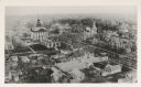
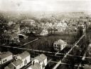
| Date: | 1890 |
|---|---|
| Description: | Aerial view of downtown Green Bay, with the old Court House. |
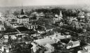
| Date: | 1890 |
|---|---|
| Description: | Aerial view of downtown Green Bay with old Court House and the surrounding buildings. |
| Date: | 1890 |
|---|---|
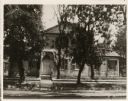
| Description: | View of the Judge Stephen R. Cotton residence. The Cotton residence was located at the corner of Jefferson and Doty Streets. |
| Date: | 1898 |
|---|---|
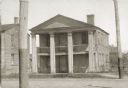
| Description: | View of the office building occupied by James Duane Doty during the 1820s when he was additional judge for the U.S. Circuit Court of Michigan Territory. Th... |

| Date: | 1890 |
|---|---|
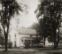
| Description: | View of the H.E. Eastmen residence. The house was located on the southwest corner of Porlier and Monroe Streets, and later the residence of Mrs. George G. ... |
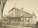
| Date: | 1890 |
|---|---|
| Description: | View of a house in a residential area, obscured by trees. "The house was built in 1835 by Ellis and was last occupied by the Misses Bessie and Barbara Hage... |
| Date: | 1870 |
|---|---|
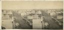
| Description: | Elevated view of Main Street and Green Bay House seen from the top of the Beaumont House. |
| Date: | 1889 |
|---|---|
| Description: | Elevated view of South Jefferson and Doty Streets, showing the Albert Weiss and Platt Greene residences and the present location of the Columbus Club, Kell... |
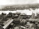
| Date: | 1889 |
|---|---|
| Description: | View of Green Bay from the top of St. Willibrord's Church. A river can be seen in the background. |
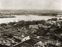
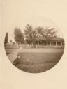
| Date: | 1889 |
|---|---|
| Description: | Southwest view of the Fox River and the waterfront. |
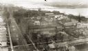
| Date: | 1889 |
|---|---|
| Description: | Elevated view of an industrial waterfront along the Fox River. |

| Date: | 1895 |
|---|---|
| Description: | Daniel H. and Joshua Whitney's residence located at 402 Main Street at the intersection of Monroe Avenue. The house was torn down in 1897. |

| Date: | 1856 |
|---|---|
| Description: | This map shows a plat of town, local streets, and parts of East and Fox Rivers. |

| Date: | 1874 |
|---|---|
| Description: | This map shows streets, buildings, railroads, the Fox River, the East River, and part of Green Bay. |

| Date: | 1835 |
|---|---|
| Description: | Map shows the Fox River, lot and block numbers, private claims, streets, a public squares, a manual labour school, and Fort Howard. An inset map shows a pl... |
If you didn't find the material you searched for, our Library Reference Staff can help.
Call our reference desk at 608-264-6535 or email us at: