Filter: Categories of Wisconsin Historical Images
Filter: Subject of Streets
Filter: Type of Map or Atlas
Filter: Categories of Wisconsin Historical Images
Filter: Subject of Streets
Filter: Type of Map or Atlas
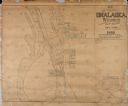
| Date: | 10 1911 |
|---|---|
| Description: | Section 2 of a Sanborn Map of Osceola. |

| Date: | 1920 |
|---|---|
| Description: | A map of Madison and the vicinity. Red lines show the street railway. |

| Date: | 1904 |
|---|---|
| Description: | This map shows a plat of the east part of the city, numbered blocks and lots, some landownership, local streets, roads, railroads, wards by number, parks, ... |

| Date: | 1920 |
|---|---|
| Description: | Map of the Nakoma neighborhood including the proposed golf grounds. |

| Date: | 1890 |
|---|---|
| Description: | Left half of a plat map of the "East Part of the city of Madison". |

| Date: | 1890 |
|---|---|
| Description: | Right side of a plat map of the "East Part of the City of Madison". |

| Date: | 1890 |
|---|---|
| Description: | Portion of a plat map of the "West Part of the City of Madison". |

| Date: | 1904 |
|---|---|
| Description: | This map shows a plat of the west part of the city, numbered blocks and lots, some landownership, local streets, roads, railroads, wards by number, parks, ... |

| Date: | 1855 |
|---|---|
| Description: | Map of the city of Madison, Dane County, published by George Harrison, surveyed and drawn by P. McCabe, and engraved by J.H. Colton & Co., New York. In add... |

| Date: | 07 01 1836 |
|---|---|
| Description: | Original plat map of the town of Madison on the four lakes. |

| Date: | |
|---|---|
| Description: | Plat map of the east central part of the city. |

| Date: | 1836 |
|---|---|
| Description: | Lots to be sold at auction by Van Antwerp and Van Dyke on Monday, 3rd Oct. 1836. The map shows plots and labeled streets. Iowa County was later split and B... |
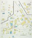
| Date: | 08 1927 |
|---|---|
| Description: | Sanborn map of Ellsworth, Wisconsin. |

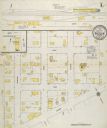
| Date: | 1912 |
|---|---|
| Description: | Sanborn insurance map of the main street in Potosi, Wisconsin, with an inset for the Potosi Brewery. |

| Date: | 1900 |
|---|---|
| Description: | A hydrographic map of Lake Monona and the adjacent topography. |

| Date: | 1883 |
|---|---|
| Description: | Bird's-eye view of Montello, county seat of Marquette County. The granite quarry, woolen mill, and planing mill are clearly identified. A steamboat on Buf... |
If you didn't find the material you searched for, our Library Reference Staff can help.
Call our reference desk at 608-264-6535 or email us at: