 Filter: Categories of Wisconsin Historical Images
Filter: Subject of Streetcars
Filter: Year of 1900-1999
Filter: Year of 1900-1909
Filter: Categories of Wisconsin Historical Images
Filter: Subject of Streetcars
Filter: Year of 1900-1999
Filter: Year of 1900-1909
| Date: | 1900 |
|---|---|
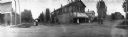
| Description: | Corner of Arndt and Doty streets, showing one of the early electric street cars in Wisconsin. The tower, the bottom of which shows in the picture, was one ... |
| Date: | 04 30 1907 |
|---|---|
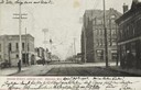
| Description: | Text on front reads: "Second Street, Looking East, Ashland, Wis." An unpaved street with two sets of streetcar tracks in the center. Buildings, storefronts... |
| Date: | 1904 |
|---|---|
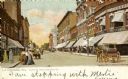
| Description: | View down street. Horse-drawn vehicles and pedestrians are on the street and sidewalks. Streetcars are further down the street. Caption reads: "Fourth St. ... |
| Date: | 1905 |
|---|---|
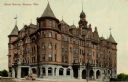
| Description: | Exterior view of Hotel Racine. Caption reads: "Hotel Racine, Racing, Wis." |

| Date: | 1908 |
|---|---|
| Description: | Panoramic view of Madison taken from Summit Avenue looking East South East toward Lake Monona. Included in the view are the Camp Randall bleachers, St. Rap... |

| Date: | 1903 |
|---|---|
| Description: | Map shows railroads, roads, street car lines, schools, churches, cemeteries, town halls, and railroad stations. Includes inset lists of: Population of Milw... |

| Date: | 1901 |
|---|---|
| Description: | This map shows public schools, engine houses, railroads, street railways, city wards, parks, block numbers, and Lake Michigan. Also included are indexes, t... |

| Date: | 1904 |
|---|---|
| Description: | This map has three inset maps of Whitefish Bay, Cudahy, and South Milwaukee. This map depicts schools, engine houses, railroads, street railways, city ward... |

| Date: | 1904 |
|---|---|
| Description: | This map shows wards, schools, engine houses, railroads, street railways, block numbers, parks, roads, and Lake Michigan. Also included are indexes: Table ... |

| Date: | 1907 |
|---|---|
| Description: | This map shows ward numbers, streets, railroads, electric car lines, parks, steam railways, section numbers, Lake Michigan and one mile concentric circles ... |
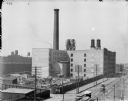
| Date: | 1900 |
|---|---|
| Description: | Elevated view of McCormick Works, with construction of wheel shop. Streetcars are along the street in the foreground. |

| Date: | 1907 |
|---|---|
| Description: | View of the streetcars on Barstow Street, with commercial buildings and pedestrians. There is a boat on the sidewalk on the right. Caption reads: "Barstow ... |

| Date: | 1906 |
|---|---|
| Description: | View of a stone Gothic-style church. A streetcar is on the left. Caption reads: "Cargill Memorial M.E. Church, Janesville, Wis." |

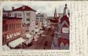
| Date: | 1907 |
|---|---|
| Description: | View down sidewalk towards the businesses along Main Street. A streetcar is coming down tracks running down the center of the street, and there are horse-d... |
| Date: | 1906 |
|---|---|
| Description: | Hand-colored, elevated view of Main Street, with a bank in the foreground on the right, and a church in the distance. Caption reads: "Main Street, La Cross... |

| Date: | 1909 |
|---|---|
| Description: | View of Main Street along the Capitol Square near the intersection with S. Carroll and S. Hamilton Streets facing west. A streetcar is coming up the street... |
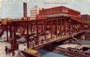
| Date: | 1909 |
|---|---|
| Description: | Color lithograph of elevated view of traffic along the Madison St. bridge. Streetcars, horse-drawn wagons, and pedestrians are on the bridge. Caption reads... |
If you didn't find the material you searched for, our Library Reference Staff can help.
Call our reference desk at 608-264-6535 or email us at: