 Filter: Categories of Wisconsin Historical Images
Filter: Subject of Streetcars
Filter: Year of 1900-1999
Filter: County of Milwaukee
Filter: Categories of Wisconsin Historical Images
Filter: Subject of Streetcars
Filter: Year of 1900-1999
Filter: County of Milwaukee
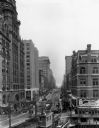
| Date: | 1930 |
|---|---|
| Description: | View down Wisconsin Avenue looking east. |

| Date: | 1911 |
|---|---|
| Description: | Three women in large hats walking away from two streetcars on a windy day. Other men and women are standing in the background. One of the streetcars has a ... |
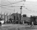
| Date: | 08 1948 |
|---|---|
| Description: | View from road of crowd of people walking towards the entrance to the Wisconsin Centennial Exposition on Greenfield Avenue. |

| Date: | 1927 |
|---|---|
| Description: | Street railway and motor bus map with a legend of "Street Car Line," "Auxiliary Bus Lines," and "Motor Bus Lines." The routes are numbered. The map reads: ... |

| Date: | 1903 |
|---|---|
| Description: | Map shows railroads, roads, street car lines, schools, churches, cemeteries, town halls, and railroad stations. Includes inset lists of: Population of Milw... |

| Date: | 1960 |
|---|---|
| Description: | Color coded map in pink, yellow, blue, and brown of Milwaukee County State and County trunk highways. The map includes a legend of symbols: "STEAM RAIL ROA... |

| Date: | 1938 |
|---|---|
| Description: | Color coded map in pink, yellow, blue, and brown of Milwaukee County State and County trunk highways. The map includes a legend of symbols: "STEAM RAIL ROA... |
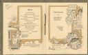
| Date: | 10 08 1914 |
|---|---|
| Description: | Interior pages of the souvenir menu for a dinner given by Mr. Edward A. Uhrig to Mr. Alvin P. Kletzsch, Mr. Emil H. Ott, and Mr. Waldemar Kremer at Republi... |

| Date: | 1901 |
|---|---|
| Description: | This map shows public schools, engine houses, railroads, street railways, city wards, parks, block numbers, and Lake Michigan. Also included are indexes, t... |

| Date: | 1904 |
|---|---|
| Description: | This map has three inset maps of Whitefish Bay, Cudahy, and South Milwaukee. This map depicts schools, engine houses, railroads, street railways, city ward... |

| Date: | 1904 |
|---|---|
| Description: | This map shows wards, schools, engine houses, railroads, street railways, block numbers, parks, roads, and Lake Michigan. Also included are indexes: Table ... |

| Date: | 1907 |
|---|---|
| Description: | This map shows ward numbers, streets, railroads, electric car lines, parks, steam railways, section numbers, Lake Michigan and one mile concentric circles ... |

| Date: | 1911 |
|---|---|
| Description: | This map shows ward numbers, streets, railroads, electric car lines, parks, steam railways, section numbers, Lake Michigan and one mile concentric circles ... |

| Date: | 1912 |
|---|---|
| Description: | This map shows ward numbers, streets, railroads, electric car lines, parks, steam railways, section numbers, Lake Michigan and one mile concentric circles ... |

| Date: | 1916 |
|---|---|
| Description: | This map shows ward numbers, streets, railroads, electric car lines, parks, steam railways, section numbers, rivers, Lake Michigan, churches, schools, and ... |

| Date: | 1910 |
|---|---|
| Description: | This ink on paper blue line print base map consists of eight separate pieces and shows city limits, The Milwaukee Electric Railroad & Light Company lines, ... |

| Date: | 1927 |
|---|---|
| Description: | This map shows highways, roads, a proposed annexation, street car lines, bus routes, local motor bus lines, a new high speed interurban, railroads, a propo... |

| Date: | 1923 |
|---|---|
| Description: | Exterior view of the Pfister and Vogel Tannery at 1531 North Water Street. A streetcar, a Red Crown Gasoline sign and pedestrians are in the foreground. |

| Date: | 1935 |
|---|---|
| Description: | Vines are growing on the facade of the Allis Chalmers factory which extends the full width of this view. There are automobiles and a street car in the back... |

| Date: | 09 03 1913 |
|---|---|
| Description: | Text on front reads: "Third St., North from Sycamore, Milwaukee, Wis." A busy city street with streetcars, automobiles, trucks and pedestrians. Many buildi... |
If you didn't find the material you searched for, our Library Reference Staff can help.
Call our reference desk at 608-264-6535 or email us at: