 Filter: Categories of Wisconsin Historical Images
Filter: Subject of Streetcars
Filter: Reproduction Rights of For Sale
Filter: County of Milwaukee
Filter: Categories of Wisconsin Historical Images
Filter: Subject of Streetcars
Filter: Reproduction Rights of For Sale
Filter: County of Milwaukee
| Date: | |
|---|---|
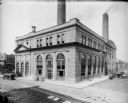
| Description: | The Oneida Street (East Wells) power plant, on the north side of Wells and east of the Milwaukee River. Presently, the building is the Milwaukee Repertory ... |

| Date: | 1927 |
|---|---|
| Description: | Street railway and motor bus map with a legend of "Street Car Line," "Auxiliary Bus Lines," and "Motor Bus Lines." The routes are numbered. The map reads: ... |

| Date: | 1960 |
|---|---|
| Description: | Color coded map in pink, yellow, blue, and brown of Milwaukee County State and County trunk highways. The map includes a legend of symbols: "STEAM RAIL ROA... |

| Date: | 1938 |
|---|---|
| Description: | Color coded map in pink, yellow, blue, and brown of Milwaukee County State and County trunk highways. The map includes a legend of symbols: "STEAM RAIL ROA... |

| Date: | 1907 |
|---|---|
| Description: | This map shows ward numbers, streets, railroads, electric car lines, parks, steam railways, section numbers, Lake Michigan and one mile concentric circles ... |

| Date: | 1916 |
|---|---|
| Description: | This map shows ward numbers, streets, railroads, electric car lines, parks, steam railways, section numbers, rivers, Lake Michigan, churches, schools, and ... |

| Date: | 1910 |
|---|---|
| Description: | This ink on paper blue line print base map consists of eight separate pieces and shows city limits, The Milwaukee Electric Railroad & Light Company lines, ... |

| Date: | 1927 |
|---|---|
| Description: | This map shows highways, roads, a proposed annexation, street car lines, bus routes, local motor bus lines, a new high speed interurban, railroads, a propo... |

| Date: | |
|---|---|
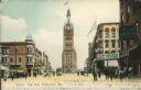
| Description: | Elevated view from City Hall Square, including the Blatz Hotel, Pabst Theater, a fountain, and a streetcar. Caption reads: "City Hall Square, Blatz Hotel a... |
| Date: | |
|---|---|
| Description: | A view of City Hall from the square, including the Miller Cafe, other businesses, pedestrians, and a streetcar. Caption reads: "City Hall, Milwaukee, Wis."... |

| Date: | 09 03 1913 |
|---|---|
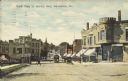
| Description: | Text on front reads: "Third St., North from Sycamore, Milwaukee, Wis." A busy city street with streetcars, automobiles, trucks and pedestrians. Many buildi... |
| Date: | 05 30 1911 |
|---|---|
| Description: | Text on front reads: "North Main St. looking West, Wauwatosa, Wis." Streetcars on an unpaved street with horse-drawn vehicles and pedestrians. The street i... |
If you didn't find the material you searched for, our Library Reference Staff can help.
Call our reference desk at 608-264-6535 or email us at: