 Filter: Categories of Wisconsin Historical Images
Filter: Subject of Street-railroads
Filter: Year of 1800-1899
Filter: Categories of Wisconsin Historical Images
Filter: Subject of Street-railroads
Filter: Year of 1800-1899
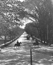
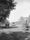
| Date: | 1896 |
|---|---|
| Description: | Tree-lined State Street from Bascom Hill on the University of Wisconsin-Madison campus. Traffic on State Street includes two well-dressed gentlemen on hors... |
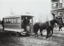
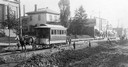
| Date: | 1890 |
|---|---|
| Description: | Man driving a horse-drawn trolley of the Milwaukee City Railroad Company on the Greenfield Avenue & Third Street line. The corner of a building advertising... |
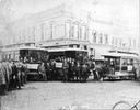
| Date: | 1890 |
|---|---|
| Description: | A large group of people posing with "Old Oshkosh," a horse-drawn streetcar, and "New Oshkosh," an electric trolley. |
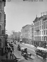
| Date: | 1885 |
|---|---|
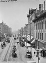
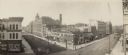
| Description: | Elevated view down East Water Street from Wisconsin Avenue, with buildings, people, and street traffic including horse-drawn vehicles and a horse-drawn str... |
| Date: | 1885 |
|---|---|
| Description: | Elevated view of buildings and street traffic. |
| Date: | 1885 |
|---|---|
| Description: | View looking up Grand Avenue from 9th Street toward two horse-drawn wagons and a horse-drawn streetcar on the tree-lined street. The wagon on the right is ... |
| Date: | 1891 |
|---|---|
| Description: | View across road construction towards a horse-drawn trolley on railroad tracks on Racine Street. Men and children are standing near piles of road building ... |
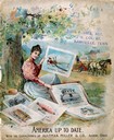
| Date: | 1896 |
|---|---|
| Description: | Front cover of an advertising catalog for Aultman, Miller and Company, manufacturers of agricultural equipment. Features a chromolithograph of a woman sit... |
| Date: | 1891 |
|---|---|
| Description: | Lithograph view of The Pabst German Stadt Theater on Oneida Street in Milwaukee, Wis. |
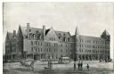
| Date: | 1886 |
|---|---|
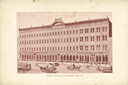
| Description: | Elevated view taken from the Miller Building, which is the original site of the old Milwaukee House. In the center of the foreground is what used to be ca... |
| Date: | 1893 |
|---|---|
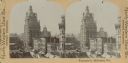
| Description: | Stereograph of Wisconsin Street looking west to Grand Avenue. |
| Date: | 02 22 1899 |
|---|---|
| Description: | The facade of the John Pritzlaff Hardware Co., on the back cover of the Old Settlers' Club Banquet Menu. |
| Date: | 1891 |
|---|---|
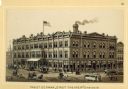
| Description: | Exterior view of the West Superior Hotel. There are pedestrians, a street car, and people riding in horse-drawn carriages on the street in front of the hot... |

| Date: | 1897 |
|---|---|
| Description: | A map of Wisconsin showing the self-supporting churches, Home Missionary churches, stations not organized, Sunday schools of C.S.S. Society, Congregational... |

| Date: | 1880 |
|---|---|
| Description: | Map created from original drawing and surveys taken by Silas Chapman. Bottom right corner features a reference key. There is a street guide on the left sid... |

| Date: | 1888 |
|---|---|
| Description: | Shows ward divisions and street railways, as well as University of Wisconsin buildings, churches, and schools. Cataloged from copy with right and left edge... |

| Date: | 1891 |
|---|---|
| Description: | This map shows railroads, electric street railways, block numbers, docks, roads, parks, light houses, selected buildings, and sites for manufacturers. The ... |

| Date: | 1894 |
|---|---|
| Description: | This map shows lot and block numbers, railroads, street car tracks, sewers, water mains, gas mains, paved streets, land owned by the Land & River Improveme... |
| Date: | 1893 |
|---|---|
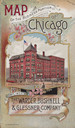
| Description: | Front cover of a brochure for Champion Mowers and Binders. Features a color illustration of the office building of the Warder, Bushnell and Glessner Compan... |

| Date: | 1897 |
|---|---|
| Description: | Two maps that show cemeteries, schools, engine houses, railroads, street railways, wards, roads, parks, block numbers, and Lake Michigan. One map has wards... |
If you didn't find the material you searched for, our Library Reference Staff can help.
Call our reference desk at 608-264-6535 or email us at: