 Filter: Categories of Wisconsin Historical Images
Filter: Subject of Street-railroads
Filter: Subject of water
Filter: Categories of Wisconsin Historical Images
Filter: Subject of Street-railroads
Filter: Subject of water
| Date: | 1904 |
|---|---|
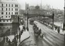
| Description: | Elevated view of wagons hauling coal from the Milwaukee Western Fuel Company holding up street car traffic on a busy Milwaukee street. |
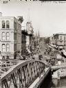
| Date: | |
|---|---|
| Description: | Elevated view of Grand Avenue and a bridge over the river, with streetcar and horse-drawn vehicles on the street. |
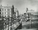
| Date: | |
|---|---|
| Description: | Elevated view over bridge and river looking up Grand Avenue. Pedestrians, horse-drawn vehicles and a street car are in the foreground. |

| Date: | 1927 |
|---|---|
| Description: | Color map, hand-drawn with comic figures engaged in various activities throughout map. Bordered by the river on the left and Lake Michigan on the right, in... |

| Date: | 1920 |
|---|---|
| Description: | A map of Madison and the vicinity. Red lines show the street railway. |
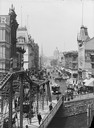
| Date: | 1900 |
|---|---|
| Description: | View looking up Wisconsin Avenue from the bridge. Many pedestrians, streetcars, and horse-drawn vehicles are visible. |
| Date: | 1900 |
|---|---|
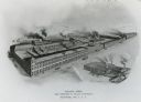
| Description: | Main factory with South Foundry in lower left. Lake Michigan is in the background. Later the Allis-Chalmers Manufacturing Co. |
| Date: | 1918 |
|---|---|
| Description: | The East Madison Chicago, Milwaukee, and St. Paul railroad station, 501 East Wilson Street, from South Hancock Street, with Lake Monona in the background. ... |

| Date: | 1918 |
|---|---|
| Description: | A view looking east along East Wilson Street with the Chicago, Milwaukee, and St. Paul East Madison railroad station, 501 East Wilson Street, on the right.... |

| Date: | 1900 |
|---|---|
| Description: | An architectural rendering of the Fauerbach Brewing Company. |
| Date: | 1901 |
|---|---|
| Description: | Lithographed poster depicting an elevated view of the Warder, Bushnell, and Glessner factory and surrounding area. Text in the upper left corner reads, "Ch... |

| Date: | |
|---|---|
| Description: | View up the Wisconsin River showing the dam and a bridge. A streetcar and a small group of people are gathered on one end. |

| Date: | 1902 |
|---|---|
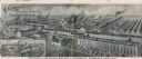
| Description: | Two panoramic bird's-eye views of the Paine Lumber Company, including the general plant, sawmill, and lumber yards. Heading at the top says: Home of Wiscon... |

| Date: | |
|---|---|
| Description: | Memohead of the Henry Rahr Sons' Company of Green Bay, Wisconsin, brewers and maltsters, with an elevated view of the main office at 1317-1323 Main St. on ... |

| Date: | |
|---|---|
| Description: | Letterhead of the John Gund Brewing Company of La Crosse, Wisconsin, with an elevated view of the brewery complex on the left. On the right is the company ... |

| Date: | 1897 |
|---|---|
| Description: | A map of Wisconsin showing the self-supporting churches, Home Missionary churches, stations not organized, Sunday schools of C.S.S. Society, Congregational... |
| Date: | 1920 |
|---|---|
| Description: | Back cover of a brochure advertising Moline Universal tractors. The text beneath an illustration of the Moline Plow Company factory reads: "The Largest Tra... |

| Date: | 1922 |
|---|---|
| Description: | A road map of Milwaukee County, Wisconsin that shows the township and range system, towns, communities, completed roads, a proposed system of roads, steam ... |

| Date: | 1903 |
|---|---|
| Description: | This 1903 map of Outagamie County, Wisconsin, shows the township and range grid, towns, sections, cities and villages, landownership and acreages, rural ma... |

| Date: | 1880 |
|---|---|
| Description: | Map created from original drawing and surveys taken by Silas Chapman. Bottom right corner features a reference key. There is a street guide on the left sid... |
If you didn't find the material you searched for, our Library Reference Staff can help.
Call our reference desk at 608-264-6535 or email us at: