 Filter: Categories of Wisconsin Historical Images
Filter: Subject of Street-railroads
Filter: Subject of recreation areas
Filter: Categories of Wisconsin Historical Images
Filter: Subject of Street-railroads
Filter: Subject of recreation areas

| Date: | 1927 |
|---|---|
| Description: | Color map, hand-drawn with comic figures engaged in various activities throughout map. Bordered by the river on the left and Lake Michigan on the right, in... |

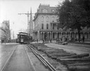
| Date: | 1900 |
|---|---|
| Description: | The State Street approach to the Wisconsin State Capitol at the turn of the century. Electric poles and street railroad wires are in the foreground. In the... |
| Date: | 1905 |
|---|---|
| Description: | Construction of new streetcar tracks on the Capitol Square. In the background, on the corner of Main and Carroll streets, is the Park Hotel. Behind the hot... |
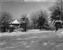
| Date: | 1900 |
|---|---|
| Description: | The inter-urban street car terminal station shelter at Irvine Park. A heavy snowfall covers the landscape. A stone wall gateway with lampposts and decorati... |

| Date: | 1960 |
|---|---|
| Description: | Color coded map in pink, yellow, blue, and brown of Milwaukee County State and County trunk highways. The map includes a legend of symbols: "STEAM RAIL ROA... |

| Date: | 1938 |
|---|---|
| Description: | Color coded map in pink, yellow, blue, and brown of Milwaukee County State and County trunk highways. The map includes a legend of symbols: "STEAM RAIL ROA... |

| Date: | 1936 |
|---|---|
| Description: | Street map of the City of Milwaukee and surrounding suburbs indicating various mass transit lines. There is an index to Milwaukee streets at the right of t... |

| Date: | 1891 |
|---|---|
| Description: | This map shows railroads, electric street railways, block numbers, docks, roads, parks, light houses, selected buildings, and sites for manufacturers. The ... |

| Date: | 1894 |
|---|---|
| Description: | This map shows lot and block numbers, railroads, street car tracks, sewers, water mains, gas mains, paved streets, land owned by the Land & River Improveme... |

| Date: | 1897 |
|---|---|
| Description: | Two maps that show cemeteries, schools, engine houses, railroads, street railways, wards, roads, parks, block numbers, and Lake Michigan. One map has wards... |

| Date: | 1899 |
|---|---|
| Description: | A map of the east part of the city of Madison, including a portion of the isthmus. |
If you didn't find the material you searched for, our Library Reference Staff can help.
Call our reference desk at 608-264-6535 or email us at: