 Filter: Categories of Wisconsin Historical Images
Filter: Subject of Street-railroads
Filter: Subject of postal service
Filter: Categories of Wisconsin Historical Images
Filter: Subject of Street-railroads
Filter: Subject of postal service
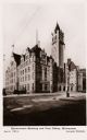
| Date: | 1905 |
|---|---|
| Description: | Tower of building is on the right. The road curves in front of the building, with trolley tracks visible. |

| Date: | 1903 |
|---|---|
| Description: | This 1903 map of Outagamie County, Wisconsin, shows the township and range grid, towns, sections, cities and villages, landownership and acreages, rural ma... |

| Date: | 1911 |
|---|---|
| Description: | Shows roads, railroads, street railways, abandoned logging railroads, rural mail routes, platted land, state forest reserves, and parts of Burnett County, ... |

| Date: | 1880 |
|---|---|
| Description: | Map created from original drawing and surveys taken by Silas Chapman. Bottom right corner features a reference key. There is a street guide on the left sid... |
If you didn't find the material you searched for, our Library Reference Staff can help.
Call our reference desk at 608-264-6535 or email us at: