 Filter: Categories of Wisconsin Historical Images
Filter: Subject of Street-railroads
Filter: Subject of land
Filter: Categories of Wisconsin Historical Images
Filter: Subject of Street-railroads
Filter: Subject of land

| Date: | 05 05 1934 |
|---|---|
| Description: | Montgomery Ward & Co. at 102 North Hamilton Street at the corner of North Pinckney and East Mifflin Streets. |
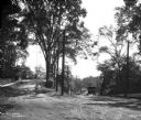
| Date: | |
|---|---|
| Description: | View toward a boy with his bicycle at the entrance to Putnam Hill Park on the left. There are telephone poles and trees in the center, street railroad trac... |
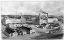
| Date: | |
|---|---|
| Description: | An engraving of an elevated view of the Leinenkugel Brewery complex with the buildings identified. A streetcar is passing by and two horses pulling wagons ... |

| Date: | 1922 |
|---|---|
| Description: | A road map of Milwaukee County, Wisconsin that shows the township and range system, towns, communities, completed roads, a proposed system of roads, steam ... |

| Date: | 1903 |
|---|---|
| Description: | This 1903 map of Outagamie County, Wisconsin, shows the township and range grid, towns, sections, cities and villages, landownership and acreages, rural ma... |

| Date: | 1931 |
|---|---|
| Description: | This map is an advertisement for Milwaukee street cars and motor buses and reads: "Ride the street car or motor bus. Economical, safe, dependable." Include... |

| Date: | 1888 |
|---|---|
| Description: | Shows ward divisions and street railways, as well as University of Wisconsin buildings, churches, and schools. Cataloged from copy with right and left edge... |

| Date: | 1938 |
|---|---|
| Description: | Color coded map in pink, yellow, blue, and brown of Milwaukee County State and County trunk highways. The map includes a legend of symbols: "STEAM RAIL ROA... |

| Date: | 1894 |
|---|---|
| Description: | This map shows lot and block numbers, railroads, street car tracks, sewers, water mains, gas mains, paved streets, land owned by the Land & River Improveme... |
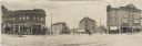
| Date: | 05 07 1907 |
|---|---|
| Description: | Panoramic view of the downtown towards Bascom Hall from the corner of the Capitol Square, showing Carroll, Mifflin, and State Streets. Several businesses c... |
If you didn't find the material you searched for, our Library Reference Staff can help.
Call our reference desk at 608-264-6535 or email us at: