 Filter: Categories of Wisconsin Historical Images
Filter: Subject of Street-railroads
Filter: Subject of lakes
Filter: Categories of Wisconsin Historical Images
Filter: Subject of Street-railroads
Filter: Subject of lakes

| Date: | 1920 |
|---|---|
| Description: | A map of Madison and the vicinity. Red lines show the street railway. |
| Date: | 1918 |
|---|---|
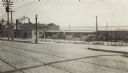
| Description: | The East Madison Chicago, Milwaukee, and St. Paul railroad station, 501 East Wilson Street, from South Hancock Street, with Lake Monona in the background. ... |

| Date: | 1918 |
|---|---|
| Description: | A view looking east along East Wilson Street with the Chicago, Milwaukee, and St. Paul East Madison railroad station, 501 East Wilson Street, on the right.... |

| Date: | 1900 |
|---|---|
| Description: | An architectural rendering of the Fauerbach Brewing Company. |

| Date: | 1897 |
|---|---|
| Description: | A map of Wisconsin showing the self-supporting churches, Home Missionary churches, stations not organized, Sunday schools of C.S.S. Society, Congregational... |

| Date: | 1903 |
|---|---|
| Description: | This 1903 map of Outagamie County, Wisconsin, shows the township and range grid, towns, sections, cities and villages, landownership and acreages, rural ma... |

| Date: | 1880 |
|---|---|
| Description: | Map created from original drawing and surveys taken by Silas Chapman. Bottom right corner features a reference key. There is a street guide on the left sid... |

| Date: | 1917 |
|---|---|
| Description: | Shows property already platted (orange), public property (green), street railway (red lines), Lake Forest development area (red), and some landownership. T... |

| Date: | 1888 |
|---|---|
| Description: | Shows ward divisions and street railways, as well as University of Wisconsin buildings, churches, and schools. Cataloged from copy with right and left edge... |

| Date: | 1909 |
|---|---|
| Description: | This map of Duluth and Superior was issued by the Duluth Street Railway Company and shows street railway routes in the cities, as well as lakes, bays, harb... |

| Date: | 1899 |
|---|---|
| Description: | A map of the east part of the city of Madison, including a portion of the isthmus. |
If you didn't find the material you searched for, our Library Reference Staff can help.
Call our reference desk at 608-264-6535 or email us at: