 Filter: Categories of Wisconsin Historical Images
Filter: Subject of Street-railroads
Filter: County of Milwaukee
Filter: Categories of Wisconsin Historical Images
Filter: Subject of Street-railroads
Filter: County of Milwaukee
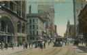
| Date: | 1911 |
|---|---|
| Description: | View of pedestrians and streetcar along Wisconsin Street. Caption reads: "Wisconsin Street, looking East from Grand Ave. Milwaukee, Wis." |
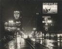
| Date: | 1951 |
|---|---|
| Description: | Wisconsin Avenue at Sixth Street, looking east from near the front of the Milwaukee Public Library (left foreground). Taken at night; lighted clocks read 9... |
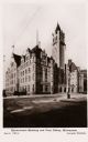
| Date: | 1905 |
|---|---|
| Description: | Tower of building is on the right. The road curves in front of the building, with trolley tracks visible. |

| Date: | |
|---|---|
| Description: | A large crowd of people ARE moving down a road. Many people are carrying umbrellas, and a flag is in the background. A sign hanging above the crowd reads: ... |
| Date: | 02 22 1899 |
|---|---|
| Description: | The facade of the John Pritzlaff Hardware Co., on the back cover of the Old Settlers' Club Banquet Menu. |

| Date: | 1915 |
|---|---|
| Description: | Milwaukee streetcar conductors posed in front of streetcars. Edwin Salber shown second row fifth person from the left. |

| Date: | 1915 |
|---|---|
| Description: | Milwaukee streetcar conductors posing in front of streetcars. On the left is Edwin Salber. |
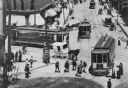
| Date: | 1901 |
|---|---|
| Description: | Elevated view of scene at the corner of Grand (Avenue?) and West Water Street, now Plankinton and Wisconsin Avenues. Several streetcars are in the streets ... |
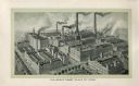
| Date: | 1907 |
|---|---|
| Description: | Engraving of an aerial view showing the Pabst Brewery plant. The streets around the plant are busy with horse-drawn vehicles and street cars. |

| Date: | |
|---|---|
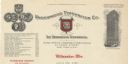
| Description: | Letterhead of Hammel, Newald & Company, a wholesale wine and liquor dealer and importer from Milwaukee, Wisconsin. On the left is a three-quarter view of t... |
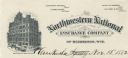
| Date: | |
|---|---|
| Description: | Letterhead of Northwestern National Insurance Company of Milwaukee, Wisconsin, with a three-quarter view of the Mitchell Building, with people walking, rid... |
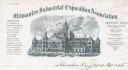
| Date: | |
|---|---|
| Description: | Letterhead of the Milwaukee Industrial Exposition Association, with a three-quarter view of the association building, people walking, riding horses, and dr... |
| Date: | |
|---|---|
| Description: | Letterhead of the Milwaukee branch of the Underwood Typewriter Company, headquartered in New York. In the center is the image of a typewriter with a red ba... |
| Date: | |
|---|---|
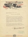
| Description: | Letterhead of the Western States Envelope Company of Milwaukee, Wisconsin, "Makers of Guaranteed Sure Stick Envelopes," with an elevated, three-quarter vie... |

| Date: | 1922 |
|---|---|
| Description: | A road map of Milwaukee County, Wisconsin that shows the township and range system, towns, communities, completed roads, a proposed system of roads, steam ... |
| Date: | |
|---|---|
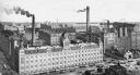
| Description: | Elevated view of the Schlitz Brewery facilities. |

| Date: | 1880 |
|---|---|
| Description: | Map created from original drawing and surveys taken by Silas Chapman. Bottom right corner features a reference key. There is a street guide on the left sid... |

| Date: | 1931 |
|---|---|
| Description: | This map is an advertisement for Milwaukee street cars and motor buses and reads: "Ride the street car or motor bus. Economical, safe, dependable." Include... |

| Date: | 1960 |
|---|---|
| Description: | Color coded map in pink, yellow, blue, and brown of Milwaukee County State and County trunk highways. The map includes a legend of symbols: "STEAM RAIL ROA... |

| Date: | 1938 |
|---|---|
| Description: | Color coded map in pink, yellow, blue, and brown of Milwaukee County State and County trunk highways. The map includes a legend of symbols: "STEAM RAIL ROA... |
If you didn't find the material you searched for, our Library Reference Staff can help.
Call our reference desk at 608-264-6535 or email us at: