Filter: Categories of Wisconsin Historical Images
Filter: Subject of Streams
Filter: Subject of water
Filter: County of Sauk
Filter: Categories of Wisconsin Historical Images
Filter: Subject of Streams
Filter: Subject of water
Filter: County of Sauk
| Date: | 07 1895 |
|---|---|
| Description: | Two men, W.M. Smith and W.H.D., rest on a large log over Little Bear Creek. |
| Date: | 1910 |
|---|---|
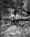
| Description: | Two girls stand in the foreground, and a man and woman sit on a log over the stream in the background at the Parfrey's Glen waterfall near Devil's Lake. |

| Date: | 1909 |
|---|---|
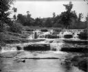
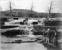
| Description: | View of Skillet Falls from downstream. The trees are bare, and tree stumps are visible on the hill in the background, known locally as Mount Baldy. |
| Date: | 1909 |
|---|---|
| Description: | Elevated view of a woman holding a walking stick and wearing a hat and fur coat with a fur stole sitting on a ledge of ice at Skillet Falls. Bare trees fra... |
| Date: | 1909 |
|---|---|
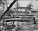
| Description: | Two well-dressed women stand at the foot of Skillet Falls. The trees in the background are bare; the hill behind is covered with tree stumps. The hill is... |
| Date: | 1909 |
|---|---|
| Description: | A well-dressed woman with a walking stick stands on ice at the partially frozen Skillet Falls. Bare trees frame the scene. There are patches of snow and tr... |
| Date: | 1909 |
|---|---|
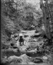
| Description: | Two women pose behind a log which has fallen across the stream in Parfrey's Glen. One woman holds a small pail. |
| Date: | 1925 |
|---|---|
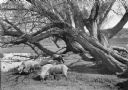
| Description: | A flock of sheep graze under old willow trees alongside a stream. |
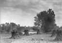
| Date: | 1925 |
|---|---|
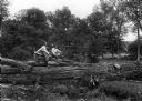
| Description: | Corn shocks stand in a field with several pumpkins on the ground. There is a stream or river along the field, and in the background is a bridge over a dam... |
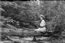
| Date: | 1915 |
|---|---|
| Description: | A young woman sits on a log which lies over a stream bed in a wooded area. |

| Date: | 1948 |
|---|---|
| Description: | This outline map of Sauk County, Wisconsin, shows the towns, cities and villages, railroads, and streams in the county. |

| Date: | 1926 |
|---|---|
| Description: | Map showing Devil's Lake State Park limits, railroads, roads, creeks, trails, and park sites. Accompanying text about the location, natural features, attra... |

| Date: | 1866 |
|---|---|
| Description: | This manuscript map by Increase Lapham shows the Dells of the Wisconsin River, from Stand Rock and Witches Gulch at the north to a point approximately one ... |

| Date: | 1915 |
|---|---|
| Description: | This 1915 map covers the section of the Wisconsin River in southern Adams, southeastern Juneau, northeastern Sauk, and northwestern Columbia counties. A po... |
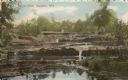
| Date: | |
|---|---|
| Description: | Colorized postcard view of Skillet Falls from downstream. Caption reads: "Skillet Falls, Baraboo, Wis." |

| Date: | 12 1903 |
|---|---|
| Description: | This manuscript blueprint map shows streets and lots and includes certifications in the left margin. Horizontal streets top to bottom are: Iroquois, Main, ... |

| Date: | 1950 |
|---|---|
| Description: | Two girls and a boy are posing standing at the edge of the pool at Pewit's Nest. The boy has rolled the legs of his overalls above his knees. There are tal... |
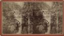
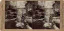
| Date: | |
|---|---|
| Description: | Elevated view stereograph of the dam at Pewit's Nest on Skillet Creek. Caption on reverse reads: "Devil's Lake and Wisconsin Scenery." |
| Date: | |
|---|---|
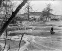
| Description: | Stereograph of a view of Pewit's Nest from above the dam. Caption at foot: "175 — Pewit's Nest above the Falls, Near Devil's Lake, Wis." |
If you didn't find the material you searched for, our Library Reference Staff can help.
Call our reference desk at 608-264-6535 or email us at: