 Filter: Categories of Wisconsin Historical Images
Filter: Subject of Streams
Filter: Subject of transportation
Filter: Categories of Wisconsin Historical Images
Filter: Subject of Streams
Filter: Subject of transportation
| Date: | 1900 |
|---|---|
| Description: | This map of Polk County, Wisconsin, from the early 20th century shows the land for sale by the Cushing Land Agency of Saint Croix Falls. The township and r... |

| Date: | 1911 |
|---|---|
| Description: | This map of Polk County, Wisconsin, from the early 20th century shows the land for sale by the Baker Land and Title Co. of Saint Croix Falls. The township ... |

| Date: | |
|---|---|
| Description: | This map from the early 20th century shows the township and range grid, towns, sections, cities and villages, railroads, roads, schools, churches, and stre... |

| Date: | |
|---|---|
| Description: | This map from the early 20th century shows the township and range grid, towns, sections, cities and villages, railroads, roads, schools, churches, cemeteri... |

| Date: | 1914 |
|---|---|
| Description: | This map of Price County, Wisconsin, from the early 20th century shows land for sale by the Homemaker Land Company of Milwaukee. The township and range sys... |

| Date: | 1910 |
|---|---|
| Description: | This map from the early 20th century shows the Wisconsin Central Railroad land grant lands owned and for sale by the Soo Line in Price County, Wisconsin, a... |

| Date: | 1914 |
|---|---|
| Description: | This 1914 map of Price County, Wisconsin, shows land for sale by the Good Land Company and Dewitt van Ostrand of Phillips. Also shown are the township and ... |

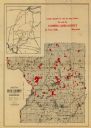
| Date: | 1858 |
|---|---|
| Description: | This 1858 map of Racine County, Wisconsin, shows land ownership and acreages, the township and range grid, towns, cities and villages, roads, railroads, sc... |

| Date: | 1896 |
|---|---|
| Description: | This 1896 map of Racine and Kenosha counties, Wisconsin, shows the township and range grid, towns, sections, cities, villages and post offices, roads, rail... |

| Date: | 1890 |
|---|---|
| Description: | This late 19th century map shows mining companies' lands and miscellaneous properties in the towns of Cady and Springfield in southeastern Saint Croix Coun... |

| Date: | 1913 |
|---|---|
| Description: | This early 20th century map of Saint Croix County, Wisconsin, shows the township and range grid, sections, towns, villages, roads, railroads, and lakes and... |

| Date: | 1948 |
|---|---|
| Description: | This outline map of Sauk County, Wisconsin, shows the towns, cities and villages, railroads, and streams in the county. |

| Date: | 1920 |
|---|---|
| Description: | This map of Sawyer County, Wisconsin, from the early 20th century shows the township and range system, towns, sections, cities and villages, railroads, hig... |

| Date: | 1897 |
|---|---|
| Description: | This 1897 map of Sawyer County, Wisconsin, shows the township and range system, sections, roads, farm houses, camps, school houses, dams, bridges, Indian r... |

| Date: | 1902 |
|---|---|
| Description: | This 1902 map of the eastern portion of Sawyer County, Wisconsin, shows the township and range system, sections, roads, farm houses, camps, school houses, ... |

| Date: | 1911 |
|---|---|
| Description: | This 1911 map of south central Sawyer County, Wisconsin, shows land for sale by Veness & Kasl of Exeland, the township and range system, sections, homes, r... |

| Date: | 1914 |
|---|---|
| Description: | This early 20th century map shows the township and range system, sections, railroads, roads, lakes, wetlands, and streams in the western Sawyer County town... |

| Date: | 1919 |
|---|---|
| Description: | This 1919 map of Sawyer County, Wisconsin, shows the township and range system, sections, cities and villages, roads, railroads, farm houses, the Indian re... |

| Date: | 1925 |
|---|---|
| Description: | This 1925 map of the northern portion of Sawyer County, Wisconsin, shows the township and range system, sections, roads, railroads, and lakes and streams i... |

| Date: | 1926 |
|---|---|
| Description: | This 1926 map of Sawyer County, Wisconsin, the township and range system, towns, sections, cities and villages, railroads, highways and roads, and lakes an... |
If you didn't find the material you searched for, our Library Reference Staff can help.
Call our reference desk at 608-264-6535 or email us at: