 Filter: Categories of Wisconsin Historical Images
Filter: Subject of Streams
Filter: Subject of transportation
Filter: Subject of land
Filter: Categories of Wisconsin Historical Images
Filter: Subject of Streams
Filter: Subject of transportation
Filter: Subject of land
| Date: | |
|---|---|
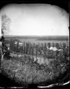
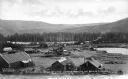
| Description: | View from hill over a valley dotted with farmsteads and a meandering stream in the foreground. A group of three or four people are posing at the opposite s... |

| Date: | 1978 |
|---|---|
| Description: | Color advertising photograph of an International Scout truck. |

| Date: | 1876 |
|---|---|
| Description: | View of a farmstead with fences, haystacks and a wooden outbuilding. Two men are posing on top of McCord Rock, one of them saluting with his hat. Another ... |

| Date: | 1874 |
|---|---|
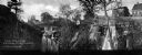
| Description: | Elevated view from hill of Clinton, now Rockdale. Three men are in the middle distance, looking east across Koshonong Creek towards a mill dam, bridge and ... |
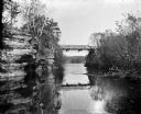
| Date: | 1909 |
|---|---|
| Description: | View from river of Dell Creek bridge with bluff and birch trees on the left. |

| Date: | 1914 |
|---|---|
| Description: | Cover of an advertising catalog for Deering Corn Machines manufactured by International Harvester. Features an illustration of a small bridge over a stream... |
| Date: | |
|---|---|
| Description: | The Milwaukee Journal Pathfinder car driving from a road onto a bridge. |
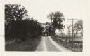
| Date: | 08 12 1961 |
|---|---|
| Description: | Early sun seeps through a tree line and buildings into a creek valley. There is a creek in the foreground. |
| Date: | 1934 |
|---|---|
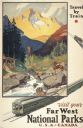
| Description: | An original lithograph promoting the national parks of the western United States and Canada, as well as promoting train travel. The poster depicts a creek... |
| Date: | 1900 |
|---|---|
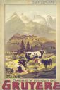
| Description: | An original colored lithograph advertising the Chemins de fer électriques de la Gruyèr railway in Switzerland. The poster features the artist Anton Reckzi... |
| Date: | |
|---|---|
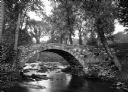
| Description: | View toward a stone bridge with arch over a stream bordered with flowers and trees on South Woodstock Road. |
| Date: | 1925 |
|---|---|
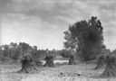
| Description: | Corn shocks stand in a field with several pumpkins on the ground. There is a stream or river along the field, and in the background is a bridge over a dam... |

| Date: | |
|---|---|
| Description: | Elevated view down hill toward old mill with a small bridge in the foreground, and another arched bridge over a steep-sided stream in City Park. Paths and ... |
| Date: | |
|---|---|
| Description: | View toward two waterfalls flowing over rocks into a ravine. One waterfall is held back by a dam and the other is traversed by a railroad bridge. Trees and... |
| Date: | |
|---|---|
| Description: | Elevated view of dredging operations at the mouth of Bear Creek in Canada. Caption reads: "Dredging Operations at the Mouth of Bear Creek, Dawson, Y.T." |
| Date: | |
|---|---|
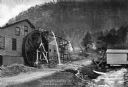
| Description: | View toward a mill with a large water wheel and spring branch, near King Solomon's Cave. A man is posed standing next to the middle of the water wheel. Cap... |

| Date: | 1930 |
|---|---|
| Description: | Pictorial map of Glacier National Park, Montana and Waterton Lakes National Park, Alberta. Illustrated by Joe Scheurle, it depicts white people, American ... |

| Date: | 1930 |
|---|---|
| Description: | The back of the pictorial map titled Recreational Map of Glacier National Park, Montana: Waterton Lakes National Park, Alberta. 14 panels of text and photo... |

| Date: | 1864 |
|---|---|
| Description: | View down to valley of Union soldiers posing on the roof of a log building. A log bridge crosses a stream, and many trees are on the hillsides. Plate 05... |

| Date: | 10 1884 |
|---|---|
| Description: | Sanborn insurance map of Black River Falls covering the area bordered by the Black River on the East, 3rd Street on the West, Johnson Street on the North, ... |
If you didn't find the material you searched for, our Library Reference Staff can help.
Call our reference desk at 608-264-6535 or email us at: