 Filter: Categories of Wisconsin Historical Images
Filter: Subject of Streams
Filter: Subject of trails
Filter: Categories of Wisconsin Historical Images
Filter: Subject of Streams
Filter: Subject of trails

| Date: | 1936 |
|---|---|
| Description: | This map is red and black ink on tracing cloth and is oriented with north to the upper left. This hand-drawn map shows a central portion of the military ro... |
| Date: | |
|---|---|
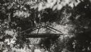
| Description: | Rustic log footbridge over a creek in the woods. |
| Date: | |
|---|---|
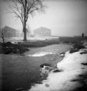
| Description: | The Root River, swollen with rainwater and/or snow melt, runs under a bridge on which a man is walking. Recently built houses are visible in the misty back... |
| Date: | |
|---|---|
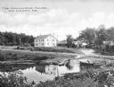
| Description: | View over stream toward the Hawthorne House, childhood home of American novelist and short story writer Nathaniel Hawthorne (7/4/1804 – 5/19/1864) built ar... |

| Date: | 1925 |
|---|---|
| Description: | This 1925 map of Ashland County, Wisconsin, shows the township and range system, towns, sections, cities and villages, the Bad River Indian Reservation, ra... |

| Date: | 1964 |
|---|---|
| Description: | This 1964 maps shows roads, boat landings and marinas, campgrounds, canoe trails and portages, and lakes and streams in parts of Vilas, Oneida, and Iron co... |

| Date: | 1974 |
|---|---|
| Description: | This 1968 map identifies resorts in the Lac du Flambeau Indian Reservation region of Wisconsin, covering parts of Iron, Vilas, Oneida, and Price counties. ... |

| Date: | 1941 |
|---|---|
| Description: | This 1941 map covers Washburn County, Wisconsin, as well as western Sawyer, eastern Burnett, and northeastern Polk counties. It shows the locations of tour... |

| Date: | 1837 |
|---|---|
| Description: | This manuscript map, copied in 1837 from a map in the Green Bay Land Office, Navarino, shows sections, the Shebowegan Trail, sandstone ledges, rivers, stre... |

| Date: | 1926 |
|---|---|
| Description: | Map showing Devil's Lake State Park limits, railroads, roads, creeks, trails, and park sites. Accompanying text about the location, natural features, attra... |

| Date: | 1898 |
|---|---|
| Description: | This 1896 map of the Chain-O-Lakes region of Waupaca County, Wisconsin, shows the lakes and streams, some topography, archaeological sites, roads, railroad... |

| Date: | 1873 |
|---|---|
| Description: | This 1873 map of Chippewa County, Wisconsin, which at the time also encompassed all or part of Price, Rusk, Sawyer, and Taylor counties, shows the township... |

| Date: | 1909 |
|---|---|
| Description: | This 1909 map of northern Wisconsin and a portion of Michigan's Upper Peninsula shows the Lac du Flambeau Indian Reservation, cities and villages, railroad... |

| Date: | 1986 |
|---|---|
| Description: | This late 1980s map of Price County, Wisconsin, shows facilities and lands open for public recreation, hunter walking trails and ski trails, campgrounds, b... |
| Date: | 08 2013 |
|---|---|
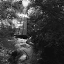
| Description: | View across rocks in a stream towards a board pathway that vanishes into the distance. Oak savanna in late summer. |

| Date: | 1920 |
|---|---|
| Description: | Text on front reads: "In Cold Water Canyon, Dells of the Wisconsin." Steps and a path next to a stream in Cold Water Canyon. The scene is fully wooded and ... |
If you didn't find the material you searched for, our Library Reference Staff can help.
Call our reference desk at 608-264-6535 or email us at: