 Filter: Categories of Wisconsin Historical Images
Filter: Subject of Streams
Filter: Subject of recreation areas
Filter: Categories of Wisconsin Historical Images
Filter: Subject of Streams
Filter: Subject of recreation areas
| Date: | |
|---|---|
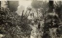
| Description: | A group of four boys in a wooded area. Two boys are standing on a small bridge, and the other two are walking along a small creek. |
| Date: | 1899 |
|---|---|
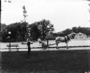
| Description: | A male grounds keeper is driving a horse-drawn mower down a path on a park or estate grounds. Another man is leaning against a slender tree. Both men are w... |
| Date: | 1934 |
|---|---|
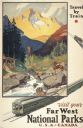
| Description: | An original lithograph promoting the national parks of the western United States and Canada, as well as promoting train travel. The poster depicts a creek... |

| Date: | |
|---|---|
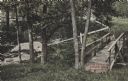
| Description: | Elevated view down hill toward old mill with a small bridge in the foreground, and another arched bridge over a steep-sided stream in City Park. Paths and ... |

| Date: | 1930 |
|---|---|
| Description: | Pictorial map of Glacier National Park, Montana and Waterton Lakes National Park, Alberta. Illustrated by Joe Scheurle, it depicts white people, American ... |

| Date: | 1930 |
|---|---|
| Description: | The back of the pictorial map titled Recreational Map of Glacier National Park, Montana: Waterton Lakes National Park, Alberta. 14 panels of text and photo... |
| Date: | 11 31 1910 |
|---|---|
| Description: | Colorized postcard view of The Spring in Decatur Park. A man is sitting near the spring. There is a bridge on the right, and many trees. Text in red in the... |
| Date: | 1910 |
|---|---|
| Description: | The mill race as it flows from Lake Mendota into Tenney Park. |

| Date: | 1946 |
|---|---|
| Description: | A map showing the roads, railroads, towns, cities and villages, streams and lakes, airports, schools, churches, cemeteries, and golf courses in Kenosha Cou... |

| Date: | 1923 |
|---|---|
| Description: | This map from the Wisconsin Lakes and Parks Association shows the area of a proposed state park, much of which is now part of the Flambeau River State Fore... |

| Date: | 1987 |
|---|---|
| Description: | This 1987 map of Racine and Kenosha counties, Wisconsin, shows towns, sections, cities and villages, zip code boundaries, highways and roads, bicycle route... |

| Date: | 1975 |
|---|---|
| Description: | This standard U.S.G.S. topographic map was annotated by civil engineer and railroad historian James P. Kaysen to show the location of existing and defunct ... |
| Date: | 1910 |
|---|---|
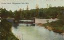
| Description: | Colorized view of a bridge crossing Duncan Creek in Irvine Park with trees and river bend in background. Caption reads: "Irvine Park, Chippewa Falls, Wis." |
| Date: | 1910 |
|---|---|
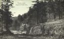
| Description: | View down tree-lined "lovers' lane" on a hill along a stone wall and rock outcroppings in Irvine Park. Caption reads: "Lovers' Lane, Irvine Park, Chippewa ... |
| Date: | 1910 |
|---|---|
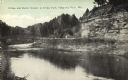
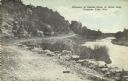
| Description: | View of a bend in Duncan Creek with a bridge, trees, a quarried rock face and road in Irvine Park (probably the "Bear Cage Road"). Caption reads: "Bridge a... |
| Date: | 1910 |
|---|---|
| Description: | A curving, rutted dirt road between a rock wall at Duncan Creek in Irvine Park (probably the "Bear Cage Road"). Caption reads: "Driveway at Duncan Creek in... |

| Date: | 1920 |
|---|---|
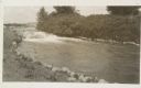
| Description: | A tree-lined rock face next to Duncan Creek in Irvine Park in Chippewa Falls. Caption reads: "A Beautiful Scene in Irvine Park, Chippewa Falls, Wis." |

| Date: | 1923 |
|---|---|
| Description: | Map showing the parcel of land on the shore of Lake Monona acquired by the City of Madison for a park (today known as Olbrich Park). |

| Date: | 1950 |
|---|---|
| Description: | View of the rustic bridge in Lakeside Park featuring railings made of branches. Caption reads: "Rustic Bridge, Lakeside Park, Fond du Lac, Wis." |

| Date: | |
|---|---|
| Description: | Elevated view of the Lake Park foot bridge, with women and children standing on it. A couple is in a rowboat below the bridge. Caption reads: "The Bridge, ... |
If you didn't find the material you searched for, our Library Reference Staff can help.
Call our reference desk at 608-264-6535 or email us at: