 Filter: Categories of Wisconsin Historical Images
Filter: Subject of Streams
Filter: Subject of mines and mineral resources
Filter: Categories of Wisconsin Historical Images
Filter: Subject of Streams
Filter: Subject of mines and mineral resources

| Date: | 1866 |
|---|---|
| Description: | A map of Lafayette County, Wisconsin, showing the townships and ranges, sections, towns, villages, stream and rivers, mounds, mineral deposits and the Mine... |

| Date: | 1890 |
|---|---|
| Description: | This late 19th century map shows mining companies' lands and miscellaneous properties in the towns of Cady and Springfield in southeastern Saint Croix Coun... |

| Date: | 1886 |
|---|---|
| Description: | This map of Ashland County, Wisconsin, which at the time included part of present-day Iron County, also covers portions of Vilas County, Wisconsin, then pa... |

| Date: | 1887 |
|---|---|
| Description: | This map shows mining properties in the Gogebic Range between Atkins Lake, in Sawyer County, Wisconsin, on the west and Lake Gogebic, Michigan, on the east... |

| Date: | 1889 |
|---|---|
| Description: | This 1889 map of Douglas County, Wisconsin, shows the township and range grid, towns, sections, cities and villages, roads, existing and proposed railroads... |

| Date: | 1892 |
|---|---|
| Description: | This 1892 map of Douglas County, Wisconsin, shows the township and range grid, towns, sections, cities and villages, roads, railroads, trails, lakes and st... |
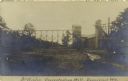
| Date: | 09 30 1907 |
|---|---|
| Description: | Photographic postcard view of the McKinley Concentrating Mill. Caption reads: "McKinley Concentrating Mill, Dodgeville, Wis." |

| Date: | 12 1903 |
|---|---|
| Description: | This manuscript blueprint map shows streets and lots and includes certifications in the left margin. Horizontal streets top to bottom are: Iroquois, Main, ... |
If you didn't find the material you searched for, our Library Reference Staff can help.
Call our reference desk at 608-264-6535 or email us at: