 Filter: Categories of Wisconsin Historical Images
Filter: Subject of Streams
Filter: Subject of land
Filter: Categories of Wisconsin Historical Images
Filter: Subject of Streams
Filter: Subject of land
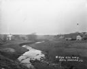
| Date: | 1920 |
|---|---|
| Description: | View from low hill of a stream flowing through fields. There are cows in the pasture on the right. In the distance is a bridge, road, and buildings. |
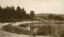
| Date: | 1920 |
|---|---|
| Description: | View along shoreline towards a rustic foot bridge which crosses the mouth of Fish Creek, which separates the village of Fish Creek from Peninsula State Par... |

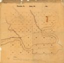
| Date: | 07 02 1836 |
|---|---|
| Description: | An ink on paper, hand-drawn map shows the sections and streams in Township 5, Range 1 east, which covers parts of the present-day towns of Mifflin and Lind... |

| Date: | 1901 |
|---|---|
| Description: | A hand-colored map of Iowa County, Wisconsin, shows townships and sections, towns, cities and villages, streams, landownership, roads, railroads and rural ... |

| Date: | |
|---|---|
| Description: | A map of Iron County, Wisconsin, shows color-coded townships, sections, lakes and streams, villages, railroads, roads, tourist camps, and La Pointe and Lac... |

| Date: | 1836 |
|---|---|
| Description: | An ink on paper, hand-drawn map of the survey of the (Township No. 8, Range No. 16 East of the 4 Meridian) Town of Ixonia, Jefferson County, Wisconsin incl... |

| Date: | 1900 |
|---|---|
| Description: | A map of Jefferson County, Wisconsin, that identifies named hills, other points of interest, and the Lake Mills moraine system in the county and identifies... |

| Date: | 1947 |
|---|---|
| Description: | An ink on paper, hand-drawn map of Jefferson County, Wisconsin, that identifies named hills, other points of interest, and the Lake Mills moraine system in... |

| Date: | |
|---|---|
| Description: | A brochure and map of Jefferson County, Wisconsin, that includes illustrations and a location map. Descriptions of points of interest are printed on the op... |

| Date: | 1931 |
|---|---|
| Description: | A topographical map from the U.S. Army Corp of Engineers showing the topography and man-made features in the Camp Williams area of the towns of Orange and ... |

| Date: | 1897 |
|---|---|
| Description: | Topographical map of Stanley McCormick's Riven Rock estate in El Montecito, Santa Barbara County, California. The map is identified as a map of a survey co... |
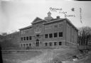
| Date: | 1913 |
|---|---|
| Description: | View of facade of high school. The grounds in front are still bare dirt. In the background is a steep hill. A small bridge is over a narrow stream on the r... |

| Date: | 1866 |
|---|---|
| Description: | A map of Lafayette County, Wisconsin, showing the townships and ranges, sections, towns, villages, stream and rivers, mounds, mineral deposits and the Mine... |

| Date: | 1915 |
|---|---|
| Description: | This 1915 map of Lincoln County, Wisconsin, shows the township and range grid, towns, cities and villages, lakes and streams, residences, churches, school ... |

| Date: | 1926 |
|---|---|
| Description: | A map of Lincoln County, Wisconsin that shows the township and range grid, towns, cities and villages, lakes and streams, residences, churches, school hous... |

| Date: | 1896 |
|---|---|
| Description: | A map of Marinette County, Wisconsin that shows the sectioning of townships and other plots, towns, cities and villages, lakes and streams, railroads, and... |

| Date: | 1923 |
|---|---|
| Description: | A hand-colored map of Marinette County, Wisconsin that shows, townships, towns and plot sections, lakes and streams, cities and villages, and rail lines an... |

| Date: | 1900 |
|---|---|
| Description: | A map of Marinette County, Wisconsin shows the township and range system, sections, towns, cities and villages, streams and lakes, railroads, roads, school... |
| Date: | |
|---|---|
| Description: | This manuscript map shows the township and range system and lakes and streams in the vicinity of the Fox River, Puckaway Lake, and Buffalo Lake in the town... |

| Date: | |
|---|---|
| Description: | A map of the western Upper Peninsula of Michigan and Wisconsin north of Lake Winnebago and east of Lake Pepin and the mouth of the Saint Louis River on Lak... |
If you didn't find the material you searched for, our Library Reference Staff can help.
Call our reference desk at 608-264-6535 or email us at: