Filter: Categories of Wisconsin Historical Images
Filter: Subject of Streams
Filter: Subject of land
Filter: Creator Name of Unknown
Filter: Categories of Wisconsin Historical Images
Filter: Subject of Streams
Filter: Subject of land
Filter: Creator Name of Unknown
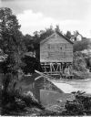
| Date: | 1900 |
|---|---|
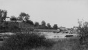
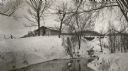
| Description: | View from shoreline of Duncan Creek, a dam, and a flour mill. |
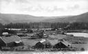
| Date: | 1920 |
|---|---|
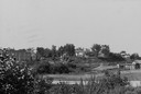
| Description: | View from shoreline of Duncan Creek, with an old dam and on the oppostie shoreline, the residence of Fred Adler, the owner of a brewery and a store in the ... |
| Date: | 1920 |
|---|---|
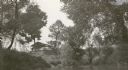
| Description: | View across water towards the C.R. Pickering Camp on Mill Creek, in summer. The shelter is on a hill overlooking the pond. |
| Date: | 1920 |
|---|---|
| Description: | C.R. Pickering Camp on Mill Creek, in winter with snow on the ground. On the opposite shoreline is a shelter on the hill overlooking the creek, with a set ... |
| Date: | |
|---|---|
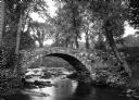
| Description: | View toward a stone bridge with arch over a stream bordered with flowers and trees on South Woodstock Road. |

| Date: | |
|---|---|
| Description: | Elevated view down hill toward old mill with a small bridge in the foreground, and another arched bridge over a steep-sided stream in City Park. Paths and ... |

| Date: | |
|---|---|
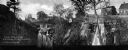
| Description: | View of Perrine's Ranch, located in the vicinity of Twin Falls. A man is crossing a stream filled with large rock boulders. The ranch is on the left side o... |
| Date: | |
|---|---|
| Description: | View toward two waterfalls flowing over rocks into a ravine. One waterfall is held back by a dam and the other is traversed by a railroad bridge. Trees and... |
| Date: | |
|---|---|
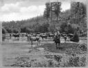
| Description: | Cattle drinking water. Trees and hills surround the area. A farmhand (cowboy) sits on his horse, looking at the camera. Caption reads: "Stock Raising in th... |
| Date: | |
|---|---|
| Description: | Elevated view of dredging operations at the mouth of Bear Creek in Canada. Caption reads: "Dredging Operations at the Mouth of Bear Creek, Dawson, Y.T." |
| Date: | |
|---|---|
| Description: | Elevated view of the banks along a fishing stream, with a few buildings on the other side of the water. Caption reads: "Great Fishing Resort Near Kirksvill... |

| Date: | |
|---|---|
| Description: | Letterhead of Madison Mobile Homes, with a three-quarter view of a mobile home parked in a clearing near a wooded area on a shoreline, with the slogan "Liv... |

| Date: | 1900 |
|---|---|
| Description: | A map of Jefferson County, Wisconsin, that identifies named hills, other points of interest, and the Lake Mills moraine system in the county and identifies... |

| Date: | |
|---|---|
| Description: | A brochure and map of Jefferson County, Wisconsin, that includes illustrations and a location map. Descriptions of points of interest are printed on the op... |
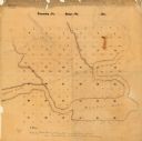
| Date: | |
|---|---|
| Description: | This manuscript map shows the township and range system and lakes and streams in the vicinity of the Fox River, Puckaway Lake, and Buffalo Lake in the town... |

| Date: | |
|---|---|
| Description: | A hand-drawn Geological map of the Upper Peninsula of Michigan, showing the counties and streams of that area. The map also identifies the location of the... |

| Date: | 1830 |
|---|---|
| Description: | A hand-drawn map of the township sectioning of Milwaukee, eastern Waukesha, northern Walworth, and Racine Counties. Other items shown in the map are the la... |

| Date: | 1976 |
|---|---|
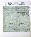
| Description: | An 1876 reprinted map of the Township of Franklin, Milwaukee County, Wisconsin, that shows the land ownership and sectioning of the town, as well as the ro... |
If you didn't find the material you searched for, our Library Reference Staff can help.
Call our reference desk at 608-264-6535 or email us at: