 Filter: Categories of Wisconsin Historical Images
Filter: Subject of Streams
Filter: Subject of human settlements
Filter: Year of 1900-1999
Filter: Categories of Wisconsin Historical Images
Filter: Subject of Streams
Filter: Subject of human settlements
Filter: Year of 1900-1999

| Date: | 1936 |
|---|---|
| Description: | This map is red and black ink on tracing cloth and is oriented with north to the upper left. This hand-drawn map shows a central portion of the military ro... |
| Date: | 1950 |
|---|---|
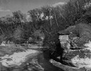
| Description: | View looking up at the Methodist Episcopal church over tree covered formations on the banks of Arkansaw Creek. |
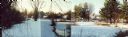
| Date: | 1955 |
|---|---|
| Description: | Wheeler Hall at Northland College, during winter. A group of people are on a bridge over the Bay City Creek, surrounded by trees, in the foreground. Wheele... |
| Date: | 1900 |
|---|---|
| Description: | View from shoreline of Duncan Creek, a dam, and a flour mill. |
| Date: | 1920 |
|---|---|
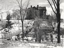
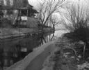
| Description: | View from shoreline of Duncan Creek, with an old dam and on the oppostie shoreline, the residence of Fred Adler, the owner of a brewery and a store in the ... |

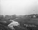
| Date: | 1950 |
|---|---|
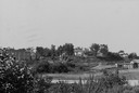
| Description: | Aerial view of main street. There is a bridge with a stream flowing under it in the foreground. |
| Date: | 1920 |
|---|---|
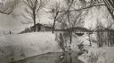
| Description: | C.R. Pickering Camp on Mill Creek, in winter with snow on the ground. On the opposite shoreline is a shelter on the hill overlooking the creek, with a set ... |
| Date: | 06 02 1943 |
|---|---|
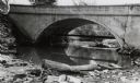
| Description: | View from shoreline of bridge and stream. |
| Date: | 06 02 1943 |
|---|---|
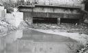
| Description: | Behind the drugstore, looking downstream. The water under the bridge is full of construction debris. |
| Date: | 01 14 1949 |
|---|---|
| Description: | Murphy's Creek (now Wingra Creek) entrance to Lake Monona, the site where 2-year-old's Toni Dussling and Haskell Furumos drowned. |
| Date: | 11 29 1989 |
|---|---|
| Description: | Panoramic view of the Union Street Bridge in the village of Rosholt created by taping three images together. |
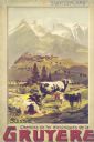
| Date: | 1900 |
|---|---|
| Description: | An original colored lithograph advertising the Chemins de fer électriques de la Gruyèr railway in Switzerland. The poster features the artist Anton Reckzi... |
| Date: | 1910 |
|---|---|
| Description: | The mill race as it flows from Lake Mendota into Tenney Park. |

| Date: | 1918 |
|---|---|
| Description: | Map of Wisconsin along with the western portion of Michigan’s Upper Peninsula, showing county lines, cities and villages, lakes, streams, and railroads. Po... |

| Date: | 1917 |
|---|---|
| Description: | A geological survey map of southeastern Wisconsin that shows the configuration of the bedrock beneath the glacial drift and other deposits in southeastern ... |

| Date: | 1917 |
|---|---|
| Description: | A geological survey map that map of southeastern Wisconsin shows the surface deposits east of the Wisconsin River, from the Illinois state line north to Ne... |

| Date: | 1912 |
|---|---|
| Description: | This map shows the area around Fort McCoy, labeled "U.S. Military Reservation," and Camp Douglas in the Sparta-Tomah region. Road, railroads, towns, cities... |
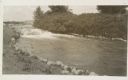
| Date: | 1920 |
|---|---|
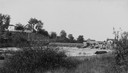
| Description: | View from low hill of a stream flowing through fields. There are cows in the pasture on the right. In the distance is a bridge, road, and buildings. |

| Date: | 1926 |
|---|---|
| Description: | A topographic map of Green County, showing by contours and spot heights the topographic and natural features of the county. The contour intervals are 20 fe... |

| Date: | 1906 |
|---|---|
| Description: | A map of Berlin, Wisconsin and the surrounding area, showing the old channel of the Fox River and the site of Mascouten village just south of that city in ... |
If you didn't find the material you searched for, our Library Reference Staff can help.
Call our reference desk at 608-264-6535 or email us at: