 Filter: Categories of Wisconsin Historical Images
Filter: Subject of Streams
Filter: Subject of human settlements
Filter: Categories of Wisconsin Historical Images
Filter: Subject of Streams
Filter: Subject of human settlements

| Date: | 1915 |
|---|---|
| Description: | This 1915 map covers the section of the Wisconsin River in southern Adams, southeastern Juneau, northeastern Sauk, and northwestern Columbia counties. A po... |

| Date: | 1992 |
|---|---|
| Description: | This 1992 map of Wood County, Wisconsin, shows towns, sections, cities and villages, highways and roads, railroads, and lakes and streams. An inset map of ... |

| Date: | 1942 |
|---|---|
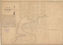
| Description: | This 1942 map of the Town of Middleton, Dane County, Wisconsin, shows sections, landowners, highways and roads, a railroad, the village of Middleton, and l... |

| Date: | 1939 |
|---|---|
| Description: | This 1939 map of Saint Croix County, Wisconsin, shows the township and range grid, cities and villages, and lakes and streams. |
| Date: | 1910 |
|---|---|
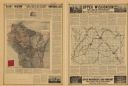
| Description: | This map from around 1916 shows the Soo Line railroad lines on a soil map of the state of Wisconsin. The map on the verso shows the township and range grid... |

| Date: | 1895 |
|---|---|
| Description: | This late 19th century map of northern Wisconsin and a portion of Michigan's Upper Peninsula shows the township and range grid, the (Lac du) Flambeau India... |

| Date: | 1909 |
|---|---|
| Description: | This 1909 map of northern Wisconsin and a portion of Michigan's Upper Peninsula shows the Lac du Flambeau Indian Reservation, cities and villages, railroad... |

| Date: | 1953 |
|---|---|
| Description: | This mid 20th century map of Vilas County and northeastern Oneida County, Wisconsin, shows the township and range grid, sections, cities and villages, rail... |

| Date: | 1899 |
|---|---|
| Description: | This 1899 map of Dodge County, Wisconsin, shows the township and range grid, towns, sections, cities and villages, roads, railroads, post offices, cemeteri... |

| Date: | 1987 |
|---|---|
| Description: | This 1987 map of Door County, Wisconsin, shows streets and roads, cities and villages, state parks, lakes and streams, and depths in Lake Michigan. A stree... |

| Date: | 1896 |
|---|---|
| Description: | This 1896 map of Douglas County, Wisconsin, shows the township and range grid, the towns of Superior, Brule, Gordon, and Nebagamain, sections, cities and v... |
| Date: | 1904 |
|---|---|
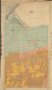
| Description: | This 1904 map from the U.S. Dept. of Agriculture's Bureau of Soils shows the soil types in north-central Douglas County, Wisconsin, and Duluth, Minnesota. ... |

| Date: | 1987 |
|---|---|
| Description: | This 1987 map of Racine and Kenosha counties, Wisconsin, shows towns, sections, cities and villages, zip code boundaries, highways and roads, bicycle route... |

| Date: | 1911 |
|---|---|
| Description: | This 1911 map from the U.S. Post Office Department shows rural delivery routes, active and discontinued post offices, selected rural landowners and houses,... |

| Date: | 1858 |
|---|---|
| Description: | This 1858 map of Rock County, Wisconsin, shows the township and range grid, towns, sections, cities and villages, railroads, roads, property owners and res... |

| Date: | 1919 |
|---|---|
| Description: | "Map no. 2, Keith and Hiles Lumber Co., Crandon, Wisconsin, Block Map, Block One... Made December 20, 1919. Maker of original map, B. McGinley. Maker of ta... |

| Date: | 1934 |
|---|---|
| Description: | This 1934 zoning map of Iron County, Wisconsin, shows the township and range grid, towns, sections, roads, and lakes and streams. Forestry and recreation d... |

| Date: | 1913 |
|---|---|
| Description: | Ink and watercolor on tracing cloth. Shows parts of Green Lake, Princeton, and Brooklyn townships, Indian mound groups, Green Lake, and other significant b... |
| Date: | 1849 |
|---|---|
| Description: | The map reads: "Dartford is centrally located in Wisconsin, on the north side of Green Lake, and in full view of that beautiful sheet of Water. Its precise... |

| Date: | 1850 |
|---|---|
| Description: | A map which includes the ink and pencil annotations showing the sections, sold parcels of land, and streams and lakes on a printed township base map for To... |
If you didn't find the material you searched for, our Library Reference Staff can help.
Call our reference desk at 608-264-6535 or email us at: