 Filter: Categories of Wisconsin Historical Images
Filter: Subject of Streams
Filter: Subject of human settlements
Filter: Categories of Wisconsin Historical Images
Filter: Subject of Streams
Filter: Subject of human settlements
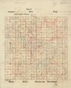
| Date: | 1860 |
|---|---|
| Description: | This manuscript map shows the surveyed areas of the Town of Aztalan, Jefferson County, Wisconsin. Acreage of the surveyed parcels is given and lakes and st... |

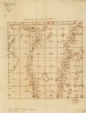
| Date: | 1915 |
|---|---|
| Description: | This 1915 map covers portions of Barron, Chippewa, and Rusk counties in Wisconsin. Shown are the township and range grid, sections, cities and villages, ra... |

| Date: | 1939 |
|---|---|
| Description: | This 1939 map of Barron County, Wisconsin, shows the township and range grid, sections, cities and villages, and lakes and streams in the county. It lacks ... |

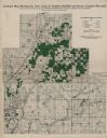
| Date: | 1917 |
|---|---|
| Description: | This map, which highlights the land for sale by the Rust-Owen Lumber Company in the towns of Drummond, Cable and Grandview, Bayfield County, Wisconsin, sho... |

| Date: | 1917 |
|---|---|
| Description: | This 1917 map of Bayfield County, Wisconsin, shows the township and range system, towns, sections, cities and villages, railroads, wagon roads, and lakes a... |
| Date: | 1915 |
|---|---|
| Description: | This early 20th century map highlights the land for sale by the American Immigration Company, Chippewa Falls, Wisconsin, in the towns of Cable, Drummond, G... |

| Date: | 1906 |
|---|---|
| Description: | This map of Sheboygan County, Wisconsin, from the early 20th century shows school districts and school locations in the county. Also shown are the township... |

| Date: | 1972 |
|---|---|
| Description: | This map of Sheboygan County, Wisconsin, shows the location of churches in the county. Churches are indexed for each town. Also shown are sections, cities ... |

| Date: | 1887 |
|---|---|
| Description: | This 1887 map of Taylor County, Wisconsin, shows the township and range system, sections, railroads, vacant Wisconsin Central Railroad land, land sold by t... |

| Date: | 1887 |
|---|---|
| Description: | This 1896 map shows the township and range system, sections, cities and villages, railroads, roads, vacant land and land sold by the Wisconsin Central Rail... |

| Date: | 1898 |
|---|---|
| Description: | This 1898 map shows the township and range system, sections, cities and villages, railroads, roads, vacant land and land sold by the Wisconsin Central Rail... |

| Date: | 1910 |
|---|---|
| Description: | This map shows the Wisconsin Central Railroad land grant lands owned and for sale by the Soo Line in Taylor County, Wisconsin, as well as in southwestern L... |
| Date: | 1900 |
|---|---|
| Description: | This map of Taylor County, Wisconsin, shows landownership, the township and range grid, towns, sections, cities and villages, railroads, tanneries, cemeter... |

| Date: | |
|---|---|
| Description: | This map of Taylor County, Wisconsin, shows soil types, the township and range grid, sections, settlers houses, schools, churches, saw mills, tanneries, ro... |

| Date: | 1940 |
|---|---|
| Description: | This map of Taylor County, Wisconsin, shows the township and range grid, towns, sections, cities and villages, railroads, roads, creameries and cheese fact... |

| Date: | 1877 |
|---|---|
| Description: | This 1877 map of Trempealeau County, Wisconsin, shows the township and range grid, sections, towns, cities and villages, land ownership and acreages, roads... |
| Date: | |
|---|---|
| Description: | This 20th century manuscript map, drawn on a printed township grid and copied from an 1878 map, shows landownership and acreages, roads, and streams in the... |

| Date: | 1878 |
|---|---|
| Description: | This 1878 map of Vernon County, Wisconsin, shows the township and range grid, sections, towns, cities and villages, land ownership and acreages, roads, rai... |
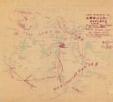
| Date: | 12 1900 |
|---|---|
| Description: | This manuscript map from 1900 shows resorts, lakes, rivers and streams, roads, railroads, and telephone lines in northwest Vilas County, in the towns of Bo... |

| Date: | 1914 |
|---|---|
| Description: | This 1914 map shows the soil types in Vilas County, Wisconsin, and adjoining areas in Oneida, Forest, and Iron counties. Also depicted are the township and... |
If you didn't find the material you searched for, our Library Reference Staff can help.
Call our reference desk at 608-264-6535 or email us at: