 Filter: Categories of Wisconsin Historical Images
Filter: Subject of Streams
Filter: Subject of human settlements
Filter: Year of 1900-1999
Filter: Year of 1910-1919
Filter: Categories of Wisconsin Historical Images
Filter: Subject of Streams
Filter: Subject of human settlements
Filter: Year of 1900-1999
Filter: Year of 1910-1919
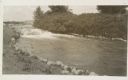
| Date: | 1910 |
|---|---|
| Description: | The mill race as it flows from Lake Mendota into Tenney Park. |

| Date: | 1918 |
|---|---|
| Description: | Map of Wisconsin along with the western portion of Michigan’s Upper Peninsula, showing county lines, cities and villages, lakes, streams, and railroads. Po... |

| Date: | 1917 |
|---|---|
| Description: | A geological survey map of southeastern Wisconsin that shows the configuration of the bedrock beneath the glacial drift and other deposits in southeastern ... |

| Date: | 1917 |
|---|---|
| Description: | A geological survey map that map of southeastern Wisconsin shows the surface deposits east of the Wisconsin River, from the Illinois state line north to Ne... |

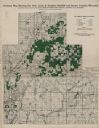
| Date: | 1912 |
|---|---|
| Description: | This map shows the area around Fort McCoy, labeled "U.S. Military Reservation," and Camp Douglas in the Sparta-Tomah region. Road, railroads, towns, cities... |

| Date: | 1915 |
|---|---|
| Description: | This 1915 map of Lincoln County, Wisconsin, shows the township and range grid, towns, cities and villages, lakes and streams, residences, churches, school ... |

| Date: | 1912 |
|---|---|
| Description: | A map of Monroe County, Wisconsin showing townships, the towns of Sparta, Tomah, Oakdale, Wilton, Cashton, Glendale, Kendall and Wyeville, as well as the U... |

| Date: | 1911 |
|---|---|
| Description: | This map of Polk County, Wisconsin, from the early 20th century shows the land for sale by the Baker Land and Title Co. of Saint Croix Falls. The township ... |

| Date: | 1914 |
|---|---|
| Description: | This map of Price County, Wisconsin, from the early 20th century shows land for sale by the Homemaker Land Company of Milwaukee. The township and range sys... |

| Date: | 1910 |
|---|---|
| Description: | This map from the early 20th century shows the Wisconsin Central Railroad land grant lands owned and for sale by the Soo Line in Price County, Wisconsin, a... |

| Date: | 1914 |
|---|---|
| Description: | This 1914 map of Price County, Wisconsin, shows land for sale by the Good Land Company and Dewitt van Ostrand of Phillips. Also shown are the township and ... |

| Date: | 1913 |
|---|---|
| Description: | This early 20th century map of Saint Croix County, Wisconsin, shows the township and range grid, sections, towns, villages, roads, railroads, and lakes and... |

| Date: | 1911 |
|---|---|
| Description: | This 1911 map of south central Sawyer County, Wisconsin, shows land for sale by Veness & Kasl of Exeland, the township and range system, sections, homes, r... |

| Date: | 1914 |
|---|---|
| Description: | This early 20th century map shows the township and range system, sections, railroads, roads, lakes, wetlands, and streams in the western Sawyer County town... |

| Date: | 1919 |
|---|---|
| Description: | This 1919 map of Sawyer County, Wisconsin, shows the township and range system, sections, cities and villages, roads, railroads, farm houses, the Indian re... |

| Date: | 1915 |
|---|---|
| Description: | This 1915 map covers portions of Barron, Chippewa, and Rusk counties in Wisconsin. Shown are the township and range grid, sections, cities and villages, ra... |

| Date: | 1917 |
|---|---|
| Description: | This map, which highlights the land for sale by the Rust-Owen Lumber Company in the towns of Drummond, Cable and Grandview, Bayfield County, Wisconsin, sho... |

| Date: | 1917 |
|---|---|
| Description: | This 1917 map of Bayfield County, Wisconsin, shows the township and range system, towns, sections, cities and villages, railroads, wagon roads, and lakes a... |
| Date: | 1915 |
|---|---|
| Description: | This early 20th century map highlights the land for sale by the American Immigration Company, Chippewa Falls, Wisconsin, in the towns of Cable, Drummond, G... |

| Date: | 1910 |
|---|---|
| Description: | This map shows the Wisconsin Central Railroad land grant lands owned and for sale by the Soo Line in Taylor County, Wisconsin, as well as in southwestern L... |
If you didn't find the material you searched for, our Library Reference Staff can help.
Call our reference desk at 608-264-6535 or email us at: