 Filter: Categories of Wisconsin Historical Images
Filter: Subject of Streams
Filter: Subject of human settlements
Filter: Subject of land
Filter: Categories of Wisconsin Historical Images
Filter: Subject of Streams
Filter: Subject of human settlements
Filter: Subject of land

| Date: | 1910 |
|---|---|
| Description: | Text on front reads: "Dell Creek, Dells of the Wisconsin, Kilbourn City, Wis." A bridge over Dell Creek. Rock formations and trees line the shore. Dell Cre... |

| Date: | 1960 |
|---|---|
| Description: | This standard U.S.G.S. topographic map was annotated by civil engineer and railroad historian James P. Kaysen to show the location of existing and defunct ... |
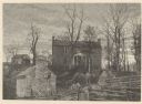
| Date: | |
|---|---|
| Description: | View looking up towards the manor house on a hill at the Walnut Grove farm. In the foreground below are fences and a small building with an external chimne... |

| Date: | 1912 |
|---|---|
| Description: | A plat map of the township of Casco. Created by Geo. A. Ogle. |
If you didn't find the material you searched for, our Library Reference Staff can help.
Call our reference desk at 608-264-6535 or email us at: