 Filter: Categories of Wisconsin Historical Images
Filter: Subject of Streams
Filter: Subject of human settlements
Filter: Subject of land
Filter: Categories of Wisconsin Historical Images
Filter: Subject of Streams
Filter: Subject of human settlements
Filter: Subject of land

| Date: | 1887 |
|---|---|
| Description: | This etching by Amidon G. Miller covers portions of the towns of Nelson and Stockholm in Pepin County, Wisconsin, as well as a portion of the Town of Maide... |
| Date: | 1863 |
|---|---|
| Description: | This plat map of Brillion is ink and pencil on paper. The front of the map shows a plat of the town, roads, and Spring Creek, and includes a significant ha... |

| Date: | 1873 |
|---|---|
| Description: | A map of the township of Primrose from the "Atlas of Dane County." |

| Date: | 1873 |
|---|---|
| Description: | A map of the township of Montrose from the "Atlas of Dane County." |

| Date: | 1938 |
|---|---|
| Description: | This map shows plat of town, boundary lines of assessors blocks, land ownership by name, local streets, railroads, wards, lots, and parts of Cedar Creek. T... |

| Date: | 1975 |
|---|---|
| Description: | This standard U.S.G.S. topographic map was annotated by civil engineer and railroad historian James P. Kaysen to show the location of existing and defunct ... |

| Date: | 1960 |
|---|---|
| Description: | This map shows lot numbers and dimensions, railroad, and streets. Fall Creek and Mill Pond (now Fall Creek Pond) are labeled. The map is a blue line print. |

| Date: | 1956 |
|---|---|
| Description: | This map shows reservation boundaries, U.S. township lines, highways, roads, rivers, and lakes. The lower left corner of the map includes a legend of "Conv... |

| Date: | 01 1969 |
|---|---|
| Description: | A map of Oneida county, which includes a small drawing of a hodag. |

| Date: | 1972 |
|---|---|
| Description: | A topographic map of the Blackwell quadrangle. |

| Date: | 1949 |
|---|---|
| Description: | Black Earth Creek in the winter, with the banks covered with snow. Large trees are leaning over the creek on the right bank. In the background are a fence,... |
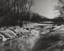
| Date: | 1951 |
|---|---|
| Description: | View along the snow-covered banks of a creek which is steaming in the extreme cold. There are trees growing in the hilly landscape, and the tops of shrubs ... |

| Date: | 1945 |
|---|---|
| Description: | Elevated view across water towards Holstein cattle in a pasture. Caption from calendar: "A Holstein dairy herd — Polk county. Wisconsin's fame as America's... |

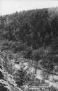
| Date: | 1945 |
|---|---|
| Description: | Text on front reads: "Meandering Stream Near Richland Center, Wis." Elevated view of a stream, probably the Pine River or a tributary, winding through a va... |
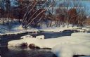
| Date: | 1950 |
|---|---|
| Description: | Text on front reads: "The Old Mill Stream in the Narrows at Rock Springs, Wis." A road and the Narrows Creek run next to each other in an elevated view of ... |
| Date: | 1950 |
|---|---|
| Description: | Text on front reads: "Greetings from Silver Cliff." On reverse it reads: "Snowbound Creek." A creek runs through snow covered woods, and a bridge is in the... |

| Date: | 1920 |
|---|---|
| Description: | Text on front reads: "Springtime in Artist's Glen, Dells of the Wisconsin River." Trees and flowers surround a stream with a rocky bank. |

| Date: | 1920 |
|---|---|
| Description: | Text on front reads: "In Cold Water Canyon, Dells of the Wisconsin." Steps and a path next to a stream in Cold Water Canyon. The scene is fully wooded and ... |
If you didn't find the material you searched for, our Library Reference Staff can help.
Call our reference desk at 608-264-6535 or email us at:

