Filter: Categories of Wisconsin Historical Images
Filter: Subject of Streams
Filter: Subject of human settlements
Filter: Subject of land
Filter: Categories of Wisconsin Historical Images
Filter: Subject of Streams
Filter: Subject of human settlements
Filter: Subject of land

| Date: | 1874 |
|---|---|
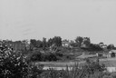
| Description: | Elevated view from hill of Clinton, now Rockdale. Three men are in the middle distance, looking east across Koshonong Creek towards a mill dam, bridge and ... |
| Date: | 1950 |
|---|---|
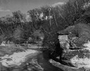
| Description: | View looking up at the Methodist Episcopal church over tree covered formations on the banks of Arkansaw Creek. |
| Date: | 1900 |
|---|---|
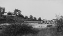
| Description: | View from shoreline of Duncan Creek, a dam, and a flour mill. |
| Date: | 1920 |
|---|---|
| Description: | View from shoreline of Duncan Creek, with an old dam and on the oppostie shoreline, the residence of Fred Adler, the owner of a brewery and a store in the ... |

| Date: | 08 10 1862 |
|---|---|
| Description: | A hand-drawn map of the Battle of Wilson's Creek, Springfield, Missouri. Other notes and locations include: "Lyon was killed instantly while heading his tr... |
| Date: | 1920 |
|---|---|
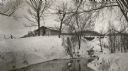
| Description: | C.R. Pickering Camp on Mill Creek, in winter with snow on the ground. On the opposite shoreline is a shelter on the hill overlooking the creek, with a set ... |
| Date: | |
|---|---|
| Description: | The Milwaukee Journal Pathfinder car driving from a road onto a bridge. |
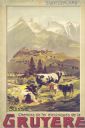
| Date: | 1900 |
|---|---|
| Description: | An original colored lithograph advertising the Chemins de fer électriques de la Gruyèr railway in Switzerland. The poster features the artist Anton Reckzi... |

| Date: | 10 1884 |
|---|---|
| Description: | Sanborn insurance map of Black River Falls covering the area bordered by the Black River on the East, 3rd Street on the West, Johnson Street on the North, ... |

| Date: | 1918 |
|---|---|
| Description: | Map of Wisconsin along with the western portion of Michigan’s Upper Peninsula, showing county lines, cities and villages, lakes, streams, and railroads. Po... |

| Date: | |
|---|---|
| Description: | Letterhead of Madison Mobile Homes, with a three-quarter view of a mobile home parked in a clearing near a wooded area on a shoreline, with the slogan "Liv... |
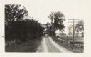
| Date: | 1920 |
|---|---|
| Description: | View from low hill of a stream flowing through fields. There are cows in the pasture on the right. In the distance is a bridge, road, and buildings. |

| Date: | 07 02 1836 |
|---|---|
| Description: | An ink on paper, hand-drawn map shows the sections and streams in Township 5, Range 1 east, which covers parts of the present-day towns of Mifflin and Lind... |

| Date: | 1901 |
|---|---|
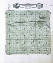
| Description: | A hand-colored map of Iowa County, Wisconsin, shows townships and sections, towns, cities and villages, streams, landownership, roads, railroads and rural ... |

| Date: | |
|---|---|
| Description: | A map of Iron County, Wisconsin, shows color-coded townships, sections, lakes and streams, villages, railroads, roads, tourist camps, and La Pointe and Lac... |

| Date: | 1836 |
|---|---|
| Description: | An ink on paper, hand-drawn map of the survey of the (Township No. 8, Range No. 16 East of the 4 Meridian) Town of Ixonia, Jefferson County, Wisconsin incl... |

| Date: | 1900 |
|---|---|
| Description: | A map of Jefferson County, Wisconsin, that identifies named hills, other points of interest, and the Lake Mills moraine system in the county and identifies... |

| Date: | 1947 |
|---|---|
| Description: | An ink on paper, hand-drawn map of Jefferson County, Wisconsin, that identifies named hills, other points of interest, and the Lake Mills moraine system in... |
If you didn't find the material you searched for, our Library Reference Staff can help.
Call our reference desk at 608-264-6535 or email us at: