 Filter: Categories of Wisconsin Historical Images
Filter: Subject of Streams
Filter: Subject of human settlements
Filter: Subject of bridges
Filter: Categories of Wisconsin Historical Images
Filter: Subject of Streams
Filter: Subject of human settlements
Filter: Subject of bridges

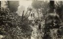
| Date: | 1874 |
|---|---|
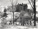
| Description: | Elevated view from hill of Clinton, now Rockdale. Three men are in the middle distance, looking east across Koshonong Creek towards a mill dam, bridge and ... |
| Date: | 1955 |
|---|---|
| Description: | Wheeler Hall at Northland College, during winter. A group of people are on a bridge over the Bay City Creek, surrounded by trees, in the foreground. Wheele... |

| Date: | 1950 |
|---|---|
| Description: | Aerial view of main street. There is a bridge with a stream flowing under it in the foreground. |
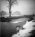
| Date: | 06 02 1943 |
|---|---|
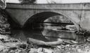
| Description: | View from shoreline of bridge and stream. |
| Date: | 06 02 1943 |
|---|---|
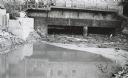
| Description: | Behind the drugstore, looking downstream. The water under the bridge is full of construction debris. |
| Date: | |
|---|---|
| Description: | The Milwaukee Journal Pathfinder car driving from a road onto a bridge. |
| Date: | |
|---|---|
| Description: | A group of four boys in a wooded area. Two boys are standing on a small bridge, and the other two are walking along a small creek. |
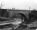
| Date: | |
|---|---|
| Description: | The Root River, swollen with rainwater and/or snow melt, runs under a bridge on which a man is walking. Recently built houses are visible in the misty back... |
| Date: | |
|---|---|
| Description: | View from shoreline of two men standing on a newly constructed railroad bridge over a stream. |
| Date: | 1920 |
|---|---|
| Description: | View from low hill of a stream flowing through fields. There are cows in the pasture on the right. In the distance is a bridge, road, and buildings. |

| Date: | 1908 |
|---|---|
| Description: | This early 20th century map shows the township and range system, sections, state-owned land, selected buildings and landownership, railroads, bridges, and ... |

| Date: | 1908 |
|---|---|
| Description: | This 1908 map shows the township and range grid, sections, towns, villages, railroads, bridges, lakes, streams, rapids, and state-owned lands in Oneida Cou... |

| Date: | 1897 |
|---|---|
| Description: | This 1897 map of Sawyer County, Wisconsin, shows the township and range system, sections, roads, farm houses, camps, school houses, dams, bridges, Indian r... |

| Date: | 1902 |
|---|---|
| Description: | This 1902 map of the eastern portion of Sawyer County, Wisconsin, shows the township and range system, sections, roads, farm houses, camps, school houses, ... |

| Date: | 1800 |
|---|---|
| Description: | This pen and ink drawing with watercolor shows the course of the Black River from Rock Creek, near Greenwood in Clark County, Wisconsin, to its confluence ... |
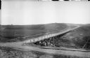
| Date: | 1918 |
|---|---|
| Description: | View looking down hill towards a roadbed and bridge constructed out of timbers that cross a small stream or river. In the distance on the far hill is a per... |
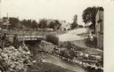
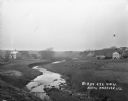
| Date: | 1908 |
|---|---|
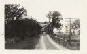
| Description: | View of a street going through the center of town. In the foreground is a stream and a bridge. Commercial buildings and dwellings are on the left. |

| Date: | 1885 |
|---|---|
| Description: | A detail of a Sanborn map including Catfish Creek and Westport Road by Lake Mendota. |

| Date: | |
|---|---|
| Description: | Elevated view of Mill Pond Lake. There is a road and bridge crossing an outlet in the foreground. Houses and other buildings are across the lake in the bac... |
| Date: | 1912 |
|---|---|
| Description: | View along stream towards people standing in front of buildings and near a stone bridge. The buildings include a post office and a feed mill. Caption reads... |
If you didn't find the material you searched for, our Library Reference Staff can help.
Call our reference desk at 608-264-6535 or email us at: