 Filter: Categories of Wisconsin Historical Images
Filter: Subject of Streams
Filter: Subject of food industry and trade
Filter: Categories of Wisconsin Historical Images
Filter: Subject of Streams
Filter: Subject of food industry and trade
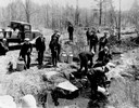
| Date: | 04 26 1936 |
|---|---|
| Description: | Planting trout in Waupaca County. Left to right on bank: S.A. LaVoilette, Joe Samz, Lloyd Pinkawski, Edwin Kargewski, W.M. Geiger, G. Moder, Billy LaVoilet... |
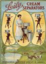
| Date: | 1913 |
|---|---|
| Description: | Advertising poster for Lily brand cream separators featuring a color illustration of a woman operating a hand crank cream separator. Below is a scene of co... |
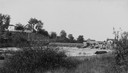
| Date: | 1900 |
|---|---|
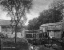
| Description: | View from shoreline of Duncan Creek, a dam, and a flour mill. |
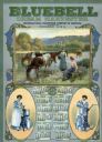
| Date: | 1913 |
|---|---|
| Description: | Calendar advertising International Harvester's Bluebell brand Cream Harvester (more commonly called a cream separator). Features a large illustration of tw... |
| Date: | 1925 |
|---|---|
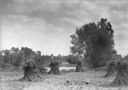
| Description: | Corn shocks stand in a field with several pumpkins on the ground. There is a stream or river along the field, and in the background is a bridge over a dam... |
| Date: | |
|---|---|
| Description: | A view of a grist mill and sawmill with a waterfall between them. Caption reads: "Grist and Saw Mill." |
| Date: | |
|---|---|
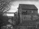
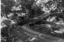
| Description: | A view of the old water mill, with a bridge over the stream in the background. Caption reads: "The Old Water Mill, Bardstown, KY." |
| Date: | |
|---|---|
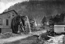
| Description: | View toward a mill with a large water wheel and spring branch, near King Solomon's Cave. A man is posed standing next to the middle of the water wheel. Cap... |

| Date: | 1896 |
|---|---|
| Description: | A hand-colored Map of Jefferson County, Wisconsin, shows township and section divisions, towns, villages and post offices, rural residents, railroads, road... |

| Date: | 1915 |
|---|---|
| Description: | This 1915 map of Lincoln County, Wisconsin, shows the township and range grid, towns, cities and villages, lakes and streams, residences, churches, school ... |

| Date: | 1926 |
|---|---|
| Description: | A map of Lincoln County, Wisconsin that shows the township and range grid, towns, cities and villages, lakes and streams, residences, churches, school hous... |

| Date: | |
|---|---|
| Description: | This 1907 map of Outagamie County, Wisconsin, shows the township and range grid, towns, sections, cities and villages, railroads, wagon roads, churches, sc... |

| Date: | 1922 |
|---|---|
| Description: | This map of Outagamie County, Wisconsin, from the first half of the 20th century, shows the township and range grid, towns, sections, cities and villages, ... |

| Date: | |
|---|---|
| Description: | This map from the early 20th century shows the township and range grid, towns, sections, cities and villages, railroads, roads, schools, churches, cemeteri... |

| Date: | 1914 |
|---|---|
| Description: | This 1914 map of Price County, Wisconsin, shows land for sale by the Good Land Company and Dewitt van Ostrand of Phillips. Also shown are the township and ... |

| Date: | 1940 |
|---|---|
| Description: | This map of Taylor County, Wisconsin, shows the township and range grid, towns, sections, cities and villages, railroads, roads, creameries and cheese fact... |

| Date: | 1896 |
|---|---|
| Description: | This late 19th century map of Walworth County, Wisconsin, shows the township and range grid, towns, sections, villages and post offices, roads, railroads, ... |

| Date: | 1928 |
|---|---|
| Description: | Shows different types of roads, railroads, schools, churches, farmsteads, cheese factories, mine shafts, old surface workings, streams, old sulphur pits, a... |
| Date: | 1930 |
|---|---|
| Description: | Map reads: "Plat showing Location of Creamery on apart of The NorthEast 1/4 of the NorthWest 1/4 of Sec 31, T. 30 N.R. 14 W. The map notes creamery buildin... |
| Date: | 12 15 1969 |
|---|---|
| Description: | This photograph was likely taken by the International Harvester Overseas Division for promotional purposes, and shows a "Suiza Dairy" International Harvest... |
If you didn't find the material you searched for, our Library Reference Staff can help.
Call our reference desk at 608-264-6535 or email us at: