 Filter: Categories of Wisconsin Historical Images
Filter: Subject of Streams
Filter: Subject of farms
Filter: Categories of Wisconsin Historical Images
Filter: Subject of Streams
Filter: Subject of farms
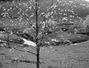
| Date: | 05 13 1962 |
|---|---|
| Description: | A twisting pasture stream as seen through a flowering tree. |
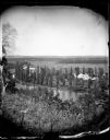
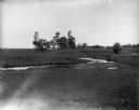
| Date: | |
|---|---|
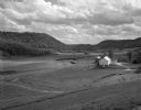
| Description: | View from hill over a valley dotted with farmsteads and a meandering stream in the foreground. A group of three or four people are posing at the opposite s... |
| Date: | 1949 |
|---|---|
| Description: | A Guernsey herd in a stream near a pasture. Trees line the banks. |
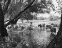
| Date: | 1912 |
|---|---|
| Description: | Advertising poster for the Dairymaid cream harvester (cream separator). Features color illustrations of grazing cows near a stream, a woman with a pail ov... |

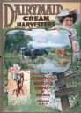
| Date: | 1930 |
|---|---|
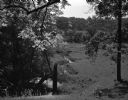
| Description: | A farm and brook in Southern Wisconsin. Several trees hang over the brook along with a trace of snow. |
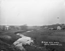
| Date: | 05 30 1962 |
|---|---|
| Description: | A country valley with a winding stream. A farmhouse with barn and silo are on the right. |
| Date: | 07 04 1965 |
|---|---|
| Description: | A rural valley with a stream running through the pasture. In the background, a farm is visible through the trees. |
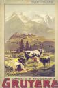
| Date: | 1900 |
|---|---|
| Description: | An original colored lithograph advertising the Chemins de fer électriques de la Gruyèr railway in Switzerland. The poster features the artist Anton Reckzi... |
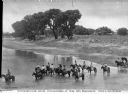
| Date: | 1908 |
|---|---|
| Description: | Elevated view of men and women on horseback in a strem. On the shoreline at the right is a horse-drawn carriage . Trees are further down the shoreline, and... |
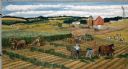
| Date: | |
|---|---|
| Description: | A threshing scene during harvest time. In the background, the separater tender stands on the thresher overseeing the whole operation. He has a weighing dev... |
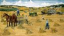
| Date: | 1980 |
|---|---|
| Description: | Farmers work cooperatively with their horse teams on silo-filling activities early in autumn. Rows of green forage are created in the fields and carried to... |
| Date: | |
|---|---|
| Description: | The Richardson Farm stands at the far edge of a farm field with a creek running through it and animals grazing. The farmhouse is white and surrounded by tr... |
| Date: | 1920 |
|---|---|
| Description: | View from low hill of a stream flowing through fields. There are cows in the pasture on the right. In the distance is a bridge, road, and buildings. |

| Date: | |
|---|---|
| Description: | A map that shows the Wisconsin Central Railway land grant lands for sale by the Soo Line, the Chicago, Milwaukee, and St. Paul Railway. Town sections, lak... |

| Date: | |
|---|---|
| Description: | Map of northern Iron County, Wisconsin, shows town sections and railroads in the towns of Saxon, Kimball, and Gurney. It also includes the area of the La P... |

| Date: | 1902 |
|---|---|
| Description: | This 1902 map of the eastern portion of Sawyer County, Wisconsin, shows the township and range system, sections, roads, farm houses, camps, school houses, ... |

| Date: | 1890 |
|---|---|
| Description: | This map shows the Wisconsin Central Railroad land grant lands owned and for sale by the Soo Line in Ashland County, Wisconsin, as well as in portions of B... |

| Date: | 1890 |
|---|---|
| Description: | This 1890s map shows the Wisconsin Central Railroad land grant lands owned and for sale by the Soo Line in Ashland County, Wisconsin, as well as in the eas... |

| Date: | 1910 |
|---|---|
| Description: | This map shows the Wisconsin Central Railroad land grant lands owned and for sale by the Soo Line in Taylor County, Wisconsin, as well as in southwestern L... |

| Date: | 1867 |
|---|---|
| Description: | This 1867 map shows the Chippewa River in northern Chippewa County, Wisconsin, from just north of Cornell to Jim Falls. Covering portions of the towns of A... |
If you didn't find the material you searched for, our Library Reference Staff can help.
Call our reference desk at 608-264-6535 or email us at: