Filter: Categories of Wisconsin Historical Images
Filter: Subject of Streams
Filter: Subject of dams
Filter: Categories of Wisconsin Historical Images
Filter: Subject of Streams
Filter: Subject of dams

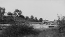
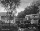
| Date: | 1874 |
|---|---|
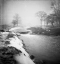
| Description: | Elevated view from hill of Clinton, now Rockdale. Three men are in the middle distance, looking east across Koshonong Creek towards a mill dam, bridge and ... |
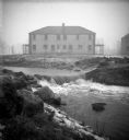
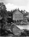
| Date: | 1900 |
|---|---|
| Description: | View from shoreline of Duncan Creek, a dam, and a flour mill. |
| Date: | 1920 |
|---|---|
| Description: | View from shoreline of Duncan Creek, with an old dam and on the oppostie shoreline, the residence of Fred Adler, the owner of a brewery and a store in the ... |
| Date: | |
|---|---|
| Description: | The Root River swollen with rainwater and/or snow melt. A recently built duplex housing unit is visible in the background. This picture was likely taken as... |
| Date: | |
|---|---|
| Description: | The Root River swollen with rainwater and/or snow melt. This picture was likely taken as a study of the water drainage in early Greendale. |
| Date: | |
|---|---|
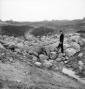
| Description: | A man stands on rocks that will dam Dale Creek. This picture was likely taken for a study of the water drainage system in early Greendale. |
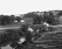
| Date: | 1925 |
|---|---|
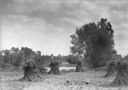
| Description: | Corn shocks stand in a field with several pumpkins on the ground. There is a stream or river along the field, and in the background is a bridge over a dam... |
| Date: | |
|---|---|
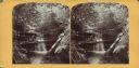
| Description: | View toward two waterfalls flowing over rocks into a ravine. One waterfall is held back by a dam and the other is traversed by a railroad bridge. Trees and... |
| Date: | |
|---|---|
| Description: | A view of a grist mill and sawmill with a waterfall between them. Caption reads: "Grist and Saw Mill." |
| Date: | |
|---|---|
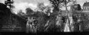
| Description: | Elevated view of the banks along a fishing stream, with a few buildings on the other side of the water. Caption reads: "Great Fishing Resort Near Kirksvill... |
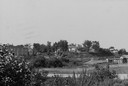
| Date: | |
|---|---|
| Description: | Elevated view of a stream with a dam and a bridge. There is a small fenced garden along the water. In the distance is a hillside with houses. |

| Date: | 1897 |
|---|---|
| Description: | This 1897 map of Sawyer County, Wisconsin, shows the township and range system, sections, roads, farm houses, camps, school houses, dams, bridges, Indian r... |

| Date: | 1902 |
|---|---|
| Description: | This 1902 map of the eastern portion of Sawyer County, Wisconsin, shows the township and range system, sections, roads, farm houses, camps, school houses, ... |

| Date: | |
|---|---|
| Description: | This map shows the township and range system, sections, dam locations, railroads, roads, selected buildings, and lakes and streams in Sawyer County, Wiscon... |

| Date: | |
|---|---|
| Description: | This map of Taylor County, Wisconsin, shows soil types, the township and range grid, sections, settlers houses, schools, churches, saw mills, tanneries, ro... |

| Date: | 1875 |
|---|---|
| Description: | One of a set of maps from G.K. Warren's 1876 Report on the transportation route along the Wisconsin and Fox rivers in the State of Wisconsin between the Mi... |

| Date: | 1873 |
|---|---|
| Description: | This 1873 map of Chippewa County, Wisconsin, which at the time also encompassed all or part of Price, Rusk, Sawyer, and Taylor counties, shows the township... |

| Date: | 1840 |
|---|---|
| Description: | This manuscript map by Increase Lapham shows the railroads, roads, wetlands, lakes and streams, dams, prairies, and settlers in the eastern half of Waukesh... |

| Date: | 1866 |
|---|---|
| Description: | This manuscript map by Increase Lapham shows the Dells of the Wisconsin River, from Stand Rock and Witches Gulch at the north to a point approximately one ... |
If you didn't find the material you searched for, our Library Reference Staff can help.
Call our reference desk at 608-264-6535 or email us at: