 Filter: Categories of Wisconsin Historical Images
Filter: Subject of Streams
Filter: Reproduction Rights of For Sale
Filter: Categories of Wisconsin Historical Images
Filter: Subject of Streams
Filter: Reproduction Rights of For Sale
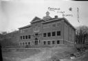
| Date: | 1913 |
|---|---|
| Description: | View of facade of high school. The grounds in front are still bare dirt. In the background is a steep hill. A small bridge is over a narrow stream on the r... |

| Date: | 1965 |
|---|---|
| Description: | Color illustration of an International Scout 800, a standard Scout engine and an optional turbocharged engine. The Scout 800 truck is shown being driven th... |

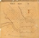
| Date: | 1866 |
|---|---|
| Description: | A map of Lafayette County, Wisconsin, showing the townships and ranges, sections, towns, villages, stream and rivers, mounds, mineral deposits and the Mine... |

| Date: | 1915 |
|---|---|
| Description: | This 1915 map of Lincoln County, Wisconsin, shows the township and range grid, towns, cities and villages, lakes and streams, residences, churches, school ... |

| Date: | 1926 |
|---|---|
| Description: | A map of Lincoln County, Wisconsin that shows the township and range grid, towns, cities and villages, lakes and streams, residences, churches, school hous... |

| Date: | 1896 |
|---|---|
| Description: | A map of Marinette County, Wisconsin that shows the sectioning of townships and other plots, towns, cities and villages, lakes and streams, railroads, and... |

| Date: | 1923 |
|---|---|
| Description: | A hand-colored map of Marinette County, Wisconsin that shows, townships, towns and plot sections, lakes and streams, cities and villages, and rail lines an... |

| Date: | 1900 |
|---|---|
| Description: | A map of Marinette County, Wisconsin shows the township and range system, sections, towns, cities and villages, streams and lakes, railroads, roads, school... |
| Date: | |
|---|---|
| Description: | This manuscript map shows the township and range system and lakes and streams in the vicinity of the Fox River, Puckaway Lake, and Buffalo Lake in the town... |

| Date: | 09 17 1959 |
|---|---|
| Description: | A map of the Menominee Indian Reservation that shows the highways, different types of roads, rivers and streams in the area. |

| Date: | 1993 |
|---|---|
| Description: | A series of three maps showing the lands of the Menominee, the first of these three maps shows the present-day Menominee Indian Reservation. Highways and r... |

| Date: | |
|---|---|
| Description: | A map of the western Upper Peninsula of Michigan and Wisconsin north of Lake Winnebago and east of Lake Pepin and the mouth of the Saint Louis River on Lak... |

| Date: | |
|---|---|
| Description: | A hand-drawn Geological map of the Upper Peninsula of Michigan, showing the counties and streams of that area. The map also identifies the location of the... |

| Date: | 1840 |
|---|---|
| Description: | An ink, watercolor, and pencil on tracing paper, hand-drawn map of Milwaukee County, Wisconsin that shows the town and range system, sections, lakes and st... |

| Date: | 1830 |
|---|---|
| Description: | A hand-drawn map of the township sectioning of Milwaukee, eastern Waukesha, northern Walworth, and Racine Counties. Other items shown in the map are the la... |

| Date: | 1844 |
|---|---|
| Description: | An ink on paper, hand-drawn map of Milwaukee County that shows the sectioning of townships, the boundary of the canal grant, roads, streams, lakes, includi... |

| Date: | 1858 |
|---|---|
| Description: | An ink on paper map of Milwaukee County and the eastern portion of Waukesha County that shows the townships of Oak Creek, Franklin, Greenfield, Wauwatosa, ... |

| Date: | 1976 |
|---|---|
| Description: | An 1876 reprinted map of the Township of Franklin, Milwaukee County, Wisconsin, that shows the land ownership and sectioning of the town, as well as the ro... |

| Date: | 1837 |
|---|---|
| Description: | A pen and ink on tracing paper, hand-drawn and colored map the proposed route of the Milwaukee and Rock River Canal, ranging from the Rock River in the wes... |

| Date: | 1838 |
|---|---|
| Description: | A map of the proposed route of the Milwaukee and Rock River Canal from Fort Atkinson on the Rock River in the west to the city of Milwaukee and Lake Michig... |
If you didn't find the material you searched for, our Library Reference Staff can help.
Call our reference desk at 608-264-6535 or email us at: