 Filter: Categories of Wisconsin Historical Images
Filter: Subject of Streams
Filter: County of Vernon
Filter: Categories of Wisconsin Historical Images
Filter: Subject of Streams
Filter: County of Vernon
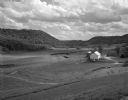
| Date: | 05 30 1962 |
|---|---|
| Description: | A country valley with a winding stream. A farmhouse with barn and silo are on the right. |
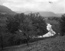
| Date: | 09 06 1964 |
|---|---|
| Description: | View down into small valley with stream. Bluffs are in the distance. |
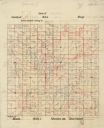
| Date: | |
|---|---|
| Description: | This 20th century manuscript map, drawn on a printed township grid and copied from an 1878 map, shows landownership and acreages, roads, and streams in the... |

| Date: | 1878 |
|---|---|
| Description: | This 1878 map of Vernon County, Wisconsin, shows the township and range grid, sections, towns, cities and villages, land ownership and acreages, roads, rai... |

| Date: | 1928 |
|---|---|
| Description: | This 1928 topographic map of Vernon County, Wisconsin, shows relief, lakes, streams and wetlands, the township and range grid, sections, cities and village... |
If you didn't find the material you searched for, our Library Reference Staff can help.
Call our reference desk at 608-264-6535 or email us at: