 Filter: Categories of Wisconsin Historical Images
Filter: Subject of Streams
Filter: County of Ozaukee
Filter: Categories of Wisconsin Historical Images
Filter: Subject of Streams
Filter: County of Ozaukee

| Date: | 1961 |
|---|---|
| Description: | This 1961 map of Ozaukee County, Wisconsin, identifies historic sites and landmarks in the county. Cities and villages, roads, and lakes and streams are al... |
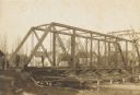
| Date: | 1906 |
|---|---|
| Description: | Steel span railroad bridge under construction over Cedar Creek. |

| Date: | 1938 |
|---|---|
| Description: | This map shows plat of town, boundary lines of assessors blocks, land ownership by name, local streets, railroads, wards, lots, and parts of Cedar Creek. T... |

| Date: | |
|---|---|
| Description: | Elevated view of Cedar Creek with a tree growing in the middle of it. There are buildings in the background. Caption reads: "Cedar Creek, Cedarburg, Wis." |

| Date: | 1905 |
|---|---|
| Description: | Hand-colored view of the Methodist Episcopal Church on Portland Avenue. Cedar Creek flows behind it. Caption reads: "M.E. Church, Cedarburg, Wis." |

| Date: | 1913 |
|---|---|
| Description: | Hand-colored view of a footbridge crossing over Cedar Creek. A man is fishing from the bridge, and a dog is standing nearby. Two boys are sitting in the gr... |

| Date: | 1910 |
|---|---|
| Description: | View down the railroad tracks, with the depot and grain elevator on the right. A bridge is crossing a stream on the left. Caption reads: "Depot & Elevator,... |
If you didn't find the material you searched for, our Library Reference Staff can help.
Call our reference desk at 608-264-6535 or email us at: