 Filter: Categories of Wisconsin Historical Images
Filter: Subject of Streams
Filter: County of Green
Filter: Categories of Wisconsin Historical Images
Filter: Subject of Streams
Filter: County of Green

| Date: | 1871 |
|---|---|
| Description: | Birds eye map of Brodhead, WI depicts street names and street locations, houses, and trees. A reference key at the bottom of the map shows the locations of... |
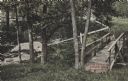
| Date: | 11 31 1910 |
|---|---|
| Description: | Colorized postcard view of The Spring in Decatur Park. A man is sitting near the spring. There is a bridge on the right, and many trees. Text in red in the... |
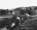
| Date: | |
|---|---|
| Description: | Elevated view of a stream with a dam and a bridge. There is a small fenced garden along the water. In the distance is a hillside with houses. |

| Date: | 1926 |
|---|---|
| Description: | A topographic map of Green County, showing by contours and spot heights the topographic and natural features of the county. The contour intervals are 20 fe... |

| Date: | 1906 |
|---|---|
| Description: | A map of Berlin, Wisconsin and the surrounding area, showing the old channel of the Fox River and the site of Mascouten village just south of that city in ... |
If you didn't find the material you searched for, our Library Reference Staff can help.
Call our reference desk at 608-264-6535 or email us at: