 Filter: Categories of Wisconsin Historical Images
Filter: Subject of Streams
Filter: County of Chippewa
Filter: Categories of Wisconsin Historical Images
Filter: Subject of Streams
Filter: County of Chippewa
| Date: | 1900 |
|---|---|
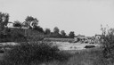
| Description: | View from shoreline of Duncan Creek, a dam, and a flour mill. |
| Date: | 1920 |
|---|---|
| Description: | View from shoreline of Duncan Creek, with an old dam and on the oppostie shoreline, the residence of Fred Adler, the owner of a brewery and a store in the ... |
| Date: | |
|---|---|
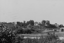
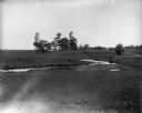
| Description: | The Richardson Farm stands at the far edge of a farm field with a creek running through it and animals grazing. The farmhouse is white and surrounded by tr... |

| Date: | 1900 |
|---|---|
| Description: | This early 20th century map of Chippewa County, Wisconsin, shows the township and range grid, towns, sections, cities and villages, roads, railroads, schoo... |

| Date: | 1918 |
|---|---|
| Description: | This 1918 map of Chippewa County, Wisconsin, shows the township and range grid, towns, sections, cities and villages, rural residences, churches, schools, ... |

| Date: | 1930 |
|---|---|
| Description: | This road map of Chippewa County, Wisconsin, dates to around 1930. It shows the township and range grid, towns, sections, cities and villages, railroads, l... |

| Date: | 1873 |
|---|---|
| Description: | This 1873 map of Chippewa County, Wisconsin, which at the time also encompassed all or part of Price, Rusk, Sawyer, and Taylor counties, shows the township... |

| Date: | 1902 |
|---|---|
| Description: | This 1902 map of Chippewa County, Wisconsin, shows the township and range grid, towns, sections, cities, villages and post offices, land ownership and acre... |

| Date: | 1975 |
|---|---|
| Description: | This standard U.S.G.S. topographic map was annotated by civil engineer and railroad historian James P. Kaysen to show the location of existing and defunct ... |
| Date: | 1910 |
|---|---|
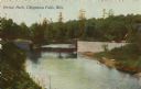
| Description: | Colorized view of a bridge crossing Duncan Creek in Irvine Park with trees and river bend in background. Caption reads: "Irvine Park, Chippewa Falls, Wis." |
| Date: | 1910 |
|---|---|
| Description: | View down tree-lined "lovers' lane" on a hill along a stone wall and rock outcroppings in Irvine Park. Caption reads: "Lovers' Lane, Irvine Park, Chippewa ... |
| Date: | 1910 |
|---|---|
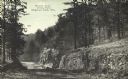
| Description: | View of a bend in Duncan Creek with a bridge, trees, a quarried rock face and road in Irvine Park (probably the "Bear Cage Road"). Caption reads: "Bridge a... |
| Date: | 1910 |
|---|---|
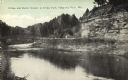
| Description: | A curving, rutted dirt road between a rock wall at Duncan Creek in Irvine Park (probably the "Bear Cage Road"). Caption reads: "Driveway at Duncan Creek in... |

| Date: | 1920 |
|---|---|
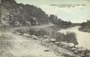
| Description: | A tree-lined rock face next to Duncan Creek in Irvine Park in Chippewa Falls. Caption reads: "A Beautiful Scene in Irvine Park, Chippewa Falls, Wis." |
If you didn't find the material you searched for, our Library Reference Staff can help.
Call our reference desk at 608-264-6535 or email us at: