Filter: Categories of Wisconsin Historical Images
Filter: Subject of Streams
Filter: County of Brown
Filter: Categories of Wisconsin Historical Images
Filter: Subject of Streams
Filter: County of Brown
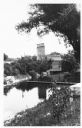
| Date: | 1920 |
|---|---|
| Description: | View from hill towards the Small mill, with adjacent stream. |

| Date: | 1890 |
|---|---|
| Description: | These hand-colored maps show the sections, lakes, swamps, streams, and state, vacant, entered, and withdrawn lands in ten survey townships in Oneida, Vilas... |

| Date: | 1908 |
|---|---|
| Description: | This 1908 map shows the township and range grid, sections, towns, villages, railroads, bridges, lakes, streams, rapids, and state-owned lands in Oneida Cou... |

| Date: | 1959 |
|---|---|
| Description: | This map identifies public forest land and industrial forest land as of 1959 in Oneida County, Wisconsin, using a 1930 base map showing the township and ra... |
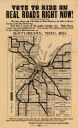
| Date: | 1919 |
|---|---|
| Description: | This flier, likely printed in 1919, promotes the vote for a bond issue to fund "hard roads" in Brown County, Wisconsin. The map shows the 135 miles of conc... |

| Date: | 1903 |
|---|---|
| Description: | Map of Brown County, Wisconsin, shows the township and range grid, towns, sections, cities, villages and post offices, land owners and acreages, railroads,... |
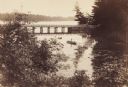
| Date: | 1889 |
|---|---|
| Description: | View from shoreline looking down on Mud Creek, about two miles above De Pere, showing small bridge and a man in a rowboat. |
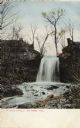
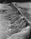
| Date: | 1900 |
|---|---|
| Description: | View looking up to the falls. Caption reads: "Kittell's Falls, De Pere, Wis." |
If you didn't find the material you searched for, our Library Reference Staff can help.
Call our reference desk at 608-264-6535 or email us at: