 Filter: Categories of Wisconsin Historical Images
Filter: Subject of Streams
Filter: Creator Name of Unknown
Filter: Year of 1900-1999
Filter: Categories of Wisconsin Historical Images
Filter: Subject of Streams
Filter: Creator Name of Unknown
Filter: Year of 1900-1999
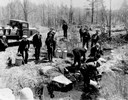
| Date: | 04 26 1936 |
|---|---|
| Description: | Planting trout in Waupaca County. Left to right on bank: S.A. LaVoilette, Joe Samz, Lloyd Pinkawski, Edwin Kargewski, W.M. Geiger, G. Moder, Billy LaVoilet... |
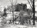
| Date: | 1955 |
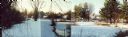
|---|---|
| Description: | Wheeler Hall at Northland College, during winter. A group of people are on a bridge over the Bay City Creek, surrounded by trees, in the foreground. Wheele... |
| Date: | 1900 |
|---|---|
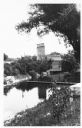
| Description: | View from shoreline of Duncan Creek, a dam, and a flour mill. |
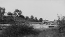
| Date: | 1920 |
|---|---|
| Description: | View from shoreline of Duncan Creek, with an old dam and on the oppostie shoreline, the residence of Fred Adler, the owner of a brewery and a store in the ... |
| Date: | 1920 |
|---|---|
| Description: | View from hill towards the Small mill, with adjacent stream. |
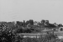
| Date: | 1920 |
|---|---|
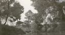
| Description: | View across water towards the C.R. Pickering Camp on Mill Creek, in summer. The shelter is on a hill overlooking the pond. |
| Date: | 1920 |
|---|---|
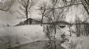
| Description: | C.R. Pickering Camp on Mill Creek, in winter with snow on the ground. On the opposite shoreline is a shelter on the hill overlooking the creek, with a set ... |
| Date: | 06 02 1943 |
|---|---|
| Description: | View from shoreline of bridge and stream. |
| Date: | 06 02 1943 |
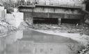
|---|---|
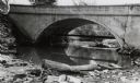
| Description: | Behind the drugstore, looking downstream. The water under the bridge is full of construction debris. |
| Date: | 11 29 1989 |
|---|---|
| Description: | Panoramic view of the Union Street Bridge in the village of Rosholt created by taping three images together. |
| Date: | 1908 |
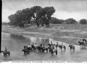
|---|---|
| Description: | Elevated view of men and women on horseback in a strem. On the shoreline at the right is a horse-drawn carriage . Trees are further down the shoreline, and... |

| Date: | 1900 |
|---|---|
| Description: | A map of Jefferson County, Wisconsin, that identifies named hills, other points of interest, and the Lake Mills moraine system in the county and identifies... |

| Date: | 1993 |
|---|---|
| Description: | A series of three maps showing the lands of the Menominee, the first of these three maps shows the present-day Menominee Indian Reservation. Highways and r... |

| Date: | 1976 |
|---|---|
| Description: | An 1876 reprinted map of the Township of Franklin, Milwaukee County, Wisconsin, that shows the land ownership and sectioning of the town, as well as the ro... |

| Date: | 1940 |
|---|---|
| Description: | This maps shows the areas in Monroe, Jackson, and Juneau counties, Wisconsin, where U.S. Army maneuvers were held in August 1940. Highways and roads, commu... |

| Date: | 1908 |
|---|---|
| Description: | This early 20th century map shows the township and range system, sections, state-owned land, selected buildings and landownership, railroads, bridges, and ... |

| Date: | 1908 |
|---|---|
| Description: | This 1908 map shows the township and range grid, sections, towns, villages, railroads, bridges, lakes, streams, rapids, and state-owned lands in Oneida Cou... |

| Date: | 1959 |
|---|---|
| Description: | This map identifies public forest land and industrial forest land as of 1959 in Oneida County, Wisconsin, using a 1930 base map showing the township and ra... |

| Date: | 1961 |
|---|---|
| Description: | This 1961 map of Ozaukee County, Wisconsin, identifies historic sites and landmarks in the county. Cities and villages, roads, and lakes and streams are al... |

| Date: | 1913 |
|---|---|
| Description: | This early 20th century map of Saint Croix County, Wisconsin, shows the township and range grid, sections, towns, villages, roads, railroads, and lakes and... |
If you didn't find the material you searched for, our Library Reference Staff can help.
Call our reference desk at 608-264-6535 or email us at: