 Filter: Categories of Wisconsin Historical Images
Filter: Subject of Streams
Filter: Creator Name of Unknown
Filter: Categories of Wisconsin Historical Images
Filter: Subject of Streams
Filter: Creator Name of Unknown

| Date: | 1774 |
|---|---|
| Description: | A hand-drawn plat map of Elkcorn (Elkhorn?) Creek. |

| Date: | 1900 |
|---|---|
| Description: | Country road crossing ford of a small stream. A rail fence runs along the left side of the road. |

| Date: | 1873 |
|---|---|
| Description: | A map of the township of Primrose from the "Atlas of Dane County." |

| Date: | 1873 |
|---|---|
| Description: | A map of the township of Montrose from the "Atlas of Dane County." |
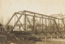
| Date: | 1906 |
|---|---|
| Description: | Steel span railroad bridge under construction over Cedar Creek. |

| Date: | 1960 |
|---|---|
| Description: | This map shows lot numbers and dimensions, railroad, and streets. Fall Creek and Mill Pond (now Fall Creek Pond) are labeled. The map is a blue line print. |

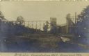
| Date: | 1910 |
|---|---|
| Description: | Elevated view of a bridge over a rocky river. In the lower left foreground people are near small, thatched roof buildings, with what appear to be wooden mi... |

| Date: | 1910 |
|---|---|
| Description: | Four people near a stream. One person standing on rocks in the stream is carrying a jug on their head. |
| Date: | 09 30 1907 |
|---|---|
| Description: | Photographic postcard view of the McKinley Concentrating Mill. Caption reads: "McKinley Concentrating Mill, Dodgeville, Wis." |
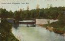
| Date: | 1910 |
|---|---|
| Description: | Colorized view of a bridge crossing Duncan Creek in Irvine Park with trees and river bend in background. Caption reads: "Irvine Park, Chippewa Falls, Wis." |
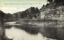
| Date: | 1910 |
|---|---|
| Description: | View of a bend in Duncan Creek with a bridge, trees, a quarried rock face and road in Irvine Park (probably the "Bear Cage Road"). Caption reads: "Bridge a... |
| Date: | 1918 |
|---|---|
| Description: | Elevated view across stream in marshy area towards a group of people gathered around an aircraft wreck. |

| Date: | 1923 |
|---|---|
| Description: | Map showing the parcel of land on the shore of Lake Monona acquired by the City of Madison for a park (today known as Olbrich Park). |

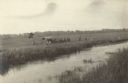
| Date: | |
|---|---|
| Description: | View from shoreline of a small group of cattle standing in a stream drinking water. There are trees and shrubs are along the opposite shoreline. |

| Date: | |
|---|---|
| Description: | Elevated view of a stream lined by tall trees and water-eroded steep, rocky cliffs. |

| Date: | |
|---|---|
| Description: | View along rocky shoreline of stream flanked by steep rock cliffs. Trees and plants are growing out of the side of the cliffs and along the tops. |

| Date: | 1955 |
|---|---|
| Description: | This map shows roads, golf courses, airports, fire towers, schools, camp grounds, rivers, streams, lakes, and railroads. The right margin of the map includ... |
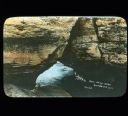
| Date: | |
|---|---|
| Description: | View looking down towards a natural rock bridge with water running beneath it. |

| Date: | |
|---|---|
| Description: | View from shoreline of a rock formation which creates a natural bridge over a river or stream. The rock is surrounded by trees. |
If you didn't find the material you searched for, our Library Reference Staff can help.
Call our reference desk at 608-264-6535 or email us at:
