 Filter: Categories of Wisconsin Historical Images
Filter: Subject of Streams
Filter: Creator Name of United States. Army. Corps of Engineers.
Filter: Categories of Wisconsin Historical Images
Filter: Subject of Streams
Filter: Creator Name of United States. Army. Corps of Engineers.
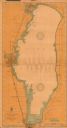
| Date: | 1908 |
|---|---|
| Description: | This 1908 chart from the U.S. Army Corps of Engineers shows contour and spot depths in Lake Winnebago. Cities and villages, roads, railroads, institutions ... |
If you didn't find the material you searched for, our Library Reference Staff can help.
Call our reference desk at 608-264-6535 or email us at: