 Filter: Categories of Wisconsin Historical Images
Filter: Subject of State parks and reserves
Filter: Categories of Wisconsin Historical Images
Filter: Subject of State parks and reserves
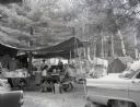
| Date: | 1960 |
|---|---|
| Description: | A campsite at Hiawatha National Forest. Men and women sits at a picnic table, while children sit by the campfire. |
| Date: | 1960 |
|---|---|
| Description: | Three men holding archery equipment at a campsite in Hiawatha National Forest. |
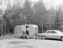
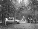
| Date: | 1960 |
|---|---|
| Description: | Two men, a woman, and a dog at a trailer in Hiawatha National Forest. |
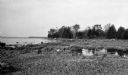
| Date: | 1925 |
|---|---|
| Description: | Rocky shoreline at Nelson Point, now in Peninsula State Park. |

| Date: | 04 1932 |
|---|---|
| Description: | This Wisconsin Conservation Department map shows federal, state, and county forest areas, the relative proportion of land owned by each agency, and state p... |

| Date: | 1923 |
|---|---|
| Description: | A small cottage is barely visible through the trees on the rocky shore at Nelson Point, now part of Peninsula State Park. |

| Date: | 06 1934 |
|---|---|
| Description: | This Wisconsin Conservation Department map shows national, state, and county forests both approved and pending, as well as Indian reservations in Wisconsin... |

| Date: | 05 1935 |
|---|---|
| Description: | This Wisconsin Conservation Department map shows the locations of state forests, state nurseries, state parks, roadside parks, prison camps, and lookout to... |

| Date: | 1936 |
|---|---|
| Description: | This pictorial tourist map from the Wisconsin Conservation Commission depicts vacation activities and identifies tourist destinations throughout the state.... |

| Date: | 1937 |
|---|---|
| Description: | This map shows the Wisconsin Conservation Department forest protection divisions and the locations of state forests, national forests, Indian reservations,... |

| Date: | 1937 |
|---|---|
| Description: | This Wisconsin Conservation Department map shows the locations of game refuges, fish hatcheries, canning factories, fish camps, and fish refuges in the sta... |

| Date: | 1937 |
|---|---|
| Description: | This Wisconsin Conservation Department map shows the locations of state forests, national forests, county forests, state nurseries, Indian reservations, st... |

| Date: | 05 01 1938 |
|---|---|
| Description: | This map shows the locations of Wisconsin Conservation Department forest protection districts and cooperative areas, state forests, national forests, India... |

| Date: | 1939 |
|---|---|
| Description: | This nine-part map from the U.S. Bureau of Public Roads identifies federal and state highways in Wisconsin by pavement type. County, forest, park, and publ... |

| Date: | 1944 |
|---|---|
| Description: | This nine-part map from the U.S. Bureau of Public Roads identifies federal and state highways in Wisconsin by pavement type. County, forest, park, and publ... |

| Date: | 1950 |
|---|---|
| Description: | This road map shows federal, state and county roads in Wisconsin, northern Illinois, northeastern Iowa, eastern Minnesota, and the western portion of Michi... |

| Date: | 1920 |
|---|---|
| Description: | View from shoreline of a water slide at Mirror Lake State Park. A woman rides down the slide into the lake, and a few people stand on the platform behind h... |
| Date: | 1920 |
|---|---|
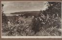
| Description: | A well-dressed man identified as Uncle Rudolph Schenck takes in the view from a bluff overlooking the Fish Creek valley and harbor. There are houses and ou... |

| Date: | |
|---|---|
| Description: | Photographic postcard view of Devil's Monument. Trees are on both sides. Text handwritten at foot: "Devil's Monument, Camp Douglas, Wis." |

| Date: | |
|---|---|
| Description: | Photographic postcard of Devil's Monument with trees surrounding it. Text handwritten at foot: "Devil's Monument, Camp Douglas, Wis. 34." |
If you didn't find the material you searched for, our Library Reference Staff can help.
Call our reference desk at 608-264-6535 or email us at: